In this article, we delve into the first leg of the medieval Via Palma pilgrimage route from Acre to Jerusalem, akin to the Santiago pilgrimage. We’ll touch on Crusader Acre and outline the itinerary from the first day walk Acre to Haifa.
Acre in Crusader times
During the Middle Ages (11th-13th centuries), Acre emerged as one of the world’s largest and most significant cities. In the era of the First Crusader Kingdom of Jerusalem, it served as the economic hub and foremost port in the Middle East, serving as both the gateway to Israel and the starting point of the Silk Road leading to the East. Acre thrived as the financial nucleus of Europe and a pivotal center for trade between the East and the West.
With the establishment of the Second Kingdom of Jerusalem, Acre’s importance soared even higher. It supplanted Jerusalem as the political, military, and religious capital of the revitalized crusader kingdom, a role it held for another century. Acre housed governmental and judicial institutions, the royal palace, tax offices, and the kingdom’s warehouses.
The Crusaders seized control of Acre and other coastal cities of Israel shortly after conquering Jerusalem, aided by naval powers such as Genoa, Pisa, and Venice. These maritime allies, perhaps motivated by trade interests, received in return tax exemptions and established their own quarters in Acre. They redirected the burgeoning international trade of the Silk Road to Acre, bypassing Constantinople and Antioch. Caravans laden with silk and spices from Damascus passed through Acre, including the famous journey of Marco Polo en route to China.
Acre’s port ranked among the finest in Israel and possibly the entire Middle East. Secure roads connected it to Damascus and onward to Mesopotamia, Iran, China, and India. By diverting international trade from Constantinople, which was controlled by the Byzantines demanding a share, Acre became a thriving commercial hub under Crusader rule.
Acre, boasting a population of approximately 100,000 residents, was a bustling international hub, particularly notable for its large size during that era. At its core lay the fortified inner harbor, serving as a departure point for numerous ships bound for the city-states of Italy. A testament to its significance, Acre was where the maritime laws of various powers were codified.
Over time, the Templars and Hospitallers, two prominent military orders, acquired territories in Acre and established their global headquarters within the city. The Hospitallers erected an expansive Castrum fortress, alongside a church and hospital, forming what is now known as the “Knights Halls.” Similarly, the Templars constructed a massive fortress at the tip of the Acre peninsula, featuring a formidable Keep tower and serving as the central bank of Europe. A hidden tunnel connected the harbor to the Templar fortress on the opposite side of the city—an engineering marvel known as the Templar tunnel.
The Templars, an order founded at the outset of the 12th century, were dedicated to protecting pilgrims. Allowed to practice usury with Christians—a prohibition in the New Testament—they essentially became Europe’s bankers. Pilgrims journeying to the Land of Israel could deposit their funds at the Templar headquarters in Paris. In exchange for a specific note, they could withdraw an equivalent amount at the Templar facility in Acre, the site of the order’s extensive gold reserves and where it provided loans to monarchs and nobility, thereby establishing Acre as Europe’s financial epicenter.
Acre was also revered as a sacred city, replete with numerous churches and named in honor of John the Baptist. In the same way that John the Baptist paved the way for Jesus’s ministry, Acre prepared pilgrims for their visit to Jerusalem. Politically, Acre served as the crusader kingdom’s secular capital, intended as a precursor to its spiritual counterpart, Jerusalem. However, with Jerusalem frequently under Muslim rule during the era of the second crusader kingdom, Acre’s significance was amplified, leading some to consider it as the earthly manifestation of the heavenly Jerusalem.
Within Acre, pilgrims could embark on a condensed pilgrimage, traversing the city from one church to another, akin to the stations of the Via Dolorosa in Jerusalem that would emerge later. This urban pilgrimage route at times sufficed as the pilgrimage itself. Among the notable stops was the purported residence of Thomas the Martyr, known as Thomas Becket, the English saint in whose honor a group of English knights established an order in Acre in 1191 following the city’s capture by Richard the Lionheart. This order was named the Knights of Saint Thomas of Acre. The connection between Thomas Becket and Acre remains a mystery, known perhaps only to God.
In 1170 Benjamin of Tudela visits Acre and leaves descriptions his journeys throughout the land and Acre itself. During the Second Kingdom of Jerusalem, a significant Jewish community develops in the City, which becomes more and more cosmopolitan and multicultural. The Tosafists – Rabbis from France and Germany immigrated to the Land of Israel beginning in 1209 and established a magnificent Beit Midrash in Acre, and the sages of Acre became known throughout the Jewish world. In 1218, Yehuda al-Kharizi made a journey in the Land of Israel and described it in his books, including the glory of Acre. In 1258, Rabbi Yechiel of Paris came from Paris to Acre and founded the large Beit Midrash DeParis in Acre, he died in 1266. The next important Jewish figure in Acre is the famous Nachmanides, who came to Israel and lived there until his death in 1270. In 1265, Nachmanides visited Acre and stayed there for five months (so it is possible that he met Rabbi Yechiel of Paris).
However, not all aspects of life in Acre during the mid-13th century were positive. A fierce conflict erupted within the city between the Venetians and the Genoese, eventually drawing in almost every faction. The Pisans threw their support behind the Venetians, while each of the two military orders backed a different side. The conflict, which became an open civil war, lasted several years, culminated in the expulsion of the Genoese from the city. This war led to the fortification of the various quarters of Acre. Compounding these difficulties, the city’s sewage was discharged into the port, earning it the unfortunate moniker “dirty sea.” This situation occasionally contributed to the spread of diseases.

Acre in the modern Era
Acre met its destruction at the hands of the Mamluks in 1291, only to be resurrected in the mid-18th century as the capital of Galilee, and subsequently as a central city under Ottoman rule in Israel. During its reconstruction, builders opted to fill the remnants of the Crusader City with sand and earth, constructing the new city atop them. This method preserved the entire lower level of the Crusader City beneath the Ottoman overlay, a preservation unmatched globally.
From the 1950s, the State of Israel began uncovering the Crusader City hidden beneath the Ottoman layer. Presently, visitors can explore the underground streets, halls, courtyards, and churches within the so-called “Crusader Halls.” In recent years, the Acre Development Company has revitalized these halls, adorning them with Crusader symbols, flags, art, workshops, and various multimedia elements to breathe life back into this historical site.
While we can’t recreate the original pilgrimage route through Crusader Acre today due to changes and much of it being lost or buried, we can still immerse ourselves in the era’s spirit. Before embarking on the “Via Palma” pilgrimage to Haifa and onward to Jerusalem, I recommend a visit the underground city and the Crusader halls beneath the citadel of Acre. Entering these vast halls, with their massive columns supporting arches and barrel vaults, transports us to another world. This space once served as the Kastrum, the Hospitaller Order’s main fortress, meticulously constructed over decades. The structure, a colossal edifice spanning one hundred meters by one hundred meters and rising several stories high, features a central courtyard surrounded by large halls.
The first hall we encounter, the largest, functioned as the communal gathering spot and dining area for all order members. Today, this expansive hall (1,200 square meters) houses exhibits that bring the lives of knights and Crusaders vividly to life, including artisan stalls like goldsmiths, displays of flags and chivalric emblems (Heraldry), and audio-visual presentations covering the pilgrimage to Israel, the military orders, and more.
Continuing from the main hall, we’ll move to the inner courtyard of the Kastrum to observe its square layout. The halls on the eastern side remain unexcavated, visible only as openings filled with earth. On the courtyard’s western side, a broad staircase catches the eye, designed to accommodate two horses ascending side by side, highlighting the functional and strategic planning of the fortress. Today, the upper floors of the Kastrum are no longer present; in their place, one can observe the rooms of the Acre prison situated above. In a corner of the courtyard, visitors will find a replica of a painting depicting the ruins as they stood until the 18th century, before the construction of the new city citadel over the old. This construction led to the courtyard and the halls being filled with earth up to the level of the new rooms. Archaeological efforts have since excavated this fill, revealing the Kastrum’s lower floor preserved in its entirety, offering a direct portal to the past and a tangible connection to the historical and architectural prowess of the Crusader era.
On the southern side of the courtyard lies another remarkable hall, enchanting and enigmatic, with its striking columns and exquisite Gothic arches supporting the ceiling. This hall, undoubtedly the most splendid within the fortress, served as the “officers’ dining room,” where distinguished guests, including kings, counts, bishops, and other high-ranking dignitaries, were entertained. On ordinary days, it functioned as the refectory, where knights and monks dined in silence, adhering to the order’s strictures, while a monk recited verses from the New Testament in the background. Architecturally, this hall is of significant interest and importance, marking a transitional phase from the Romanesque to the Gothic style. Guests from other orders, diplomats, and businessmen were also welcomed in this grand hall, where agreements were signed, festive meals celebrated, and holidays observed. One can only imagine the impressive gatherings of hundreds of members of the order in this central space. The Hospitallers were a wealthy and powerful order, hosting European monarchs at their Acre headquarters. It’s believed that Louis IX, King of France, who resided in Israel from 1250 to 1254, commissioned the construction of the refectory. Notably, at the northeastern end of the hall, at the base of an arch, the Fleur de Lis—a symbol associated with the French monarchy—is engraved, supporting this theory.
The Kastrum was the international hub of the Hospitaller Order, which held numerous estates across Europe, the Middle East, and Israel, as well as the focal point of the Order’s activities in Israel, including a network of fortresses primarily along the border regions. It housed the Order’s headquarters, main storages, stables, treasury and finance departments, and the library, among other critical functions, cementing its role as a vital center of administration. The Hospitallers established branches across Europe, organizing groups of fighting monks, or “nuclei,” alongside teams of doctors and medical aid workers dispatched on service missions to the Land of Israel. These nuclei consisted of cohorts of young individuals raised within one of the order’s European monasteries, where they were versed in religious, medical, and military disciplines, embodying the multifaceted mission of the Hospitallers in their service to the Land of Israel and beyond.
Once the nucleus had formed and gained experience through local activities and service in Europe, they were dispatched to carry out missions in the Holy Land. Arriving at the Kastrum, they would reside there for several weeks or months to undergo additional training pertinent to their mission and roles. This preparation included learning basic Arabic phrases, understanding local customs, exploring the region, familiarizing themselves with the organization’s structure and the strategic layout of local fortifications, comprehending the command hierarchy, and acquiring horses, weapons, medical supplies, and armor from the storages. They would also acquaint themselves with the local flora and fauna among other regional specifics. Following this comprehensive training, the groups were ready to embark on their assigned missions, stationed at various fortresses along the border. They maintained a continuous connection with the central hub in Acre, periodically returning for rest periods, reorganization, and resupply. This cycle ensured that the Hospitallers were well-prepared, informed, and equipped to fulfill their duties in the Holy Land, reinforcing their presence and operational efficiency in the region.
Leaving the refectory to return to the courtyard, we’ll venture into the halls on the north side. Here, we encounter ten large, longitudinal halls characterized by their barrel-vaulted ceilings. The rationale behind these architectural features is that these halls served as warehouses. It’s plausible that each hall was linked to one of the citadels scattered across the country, acting as a repository for the supplies incoming from various overseas countries destined for that particular citadel. The teams designated for different fortresses resided in the rooms on the upper floors, while the lower floor functioned as a storage area for equipment. Presently, these halls house exhibitions that narrate the history of Acre, alongside a display of paintings.
Exiting back to the courtyard and near the entrance to the grand feasting hall, we’ll find an opening to a sewer tunnel that once ran from the Kastrum to the sea. Rest assured, it has been inactive for 800 years. Venturing through this tunnel, we emerge into a vast underground space that served as the crypt of the Hospitaller Order’s mother church. Within this crypt are the tombstones of knights and leaders of the order, interred there in the late 13th century. The inscriptions and tombstones transport us back to an era of knights, dragons, and damsels in distress, a time when the lines between good and evil were distinctly drawn, and life was imbued with meaning. Adorning the walls of the crypt are paintings that depict scenes from the period’s books, including representations of God as an architect, the construction of Solomon’s Temple, monks attempting to ascend the mystical ladder, the wheel of the seasons, and the figure of man as a microcosm of creation, among others. These artworks signal a resurgence of mysticism and cosmology in Christianity during this period, offering a rich tapestry of the spiritual and cultural underpinnings that influenced the lives and beliefs of the Hospitaller knights and their contemporaries.
Emerging from the crypt halls of the church, we delve into the underground streets of the Hospitaller district in Crusader Acre, arriving at a magnificent hall called “the beautiful hall”. This recent addition to the knights’ halls stands out for its exceptional masonry quality, spatial proportions, and symmetry, reflecting the advancements in construction techniques and architectural principles likely achieved in Israel during the Second Crusader Kingdom. These halls mark a resurgence of sacred architectural concepts, employing sacred proportions and measurements that hark back to ancient building traditions. The Hospitallers were renowned for their construction prowess, honing their skills in monumental building through interactions with the Armenians, Arabs, and Byzantines during their tenure in Israel. They erected many of the Crusaders’ stunning fortresses, such as Belvoir Castle in the Jordan Valley. Their architectural journey continued upon their return to Europe, where they contributed to the construction of Gothic cathedrals. This legacy of architectural innovation and excellence traces its roots back to Acre, serving as a testament to the Hospitallers’ lasting impact on the architectural landscape of the medieval world.
In addition to the sites within the Hospitaller district, Acre is home to several other landmarks dating back to the Crusader period. Among these is the Templar Tunnel, an underground passageway extending from the harbor to the site of the Templar citadel on the opposite side of the peninsula. Various remnants from this era are scattered throughout the city, many of which have been integrated into Ottoman structures. Underneath Acre’s predominantly Ottoman-layered contemporary cityscape, evidence of the Crusader City persists in numerous locations. For instance, beneath the great mosque of al-Jazar lie vast water reservoirs originating from the Crusader period. These reservoirs were likely integral to the water supply system of the royal palace, showcasing the sophisticated infrastructure that supported the city’s inhabitants during the Crusades.
The first day of Pilgrimage: Acre to Haifa
The pilgrimage starts with a departure from Acre’s walls, moving eastward to Tel Napoleon, known as ancient Tel Acre. This spot marks the original location of the city before it was moved to where it stands today, some 2400 years ago. Acre, one of the world’s most ancient cities, was established at the dawn of the Bronze Age (around 3300 BC). It was considered sacred by the Canaanites and Phoenicians, associated with the goddess Anat, and featured in the myths of the ancient Greeks. A pilgrim named Teitmer documented that the Crusaders held the belief that the tomb of Memnon, the Ethiopian king who sided with Priam of Troy in his battle against the Greeks, was located near Acre.
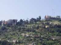
In the time of the Crusaders, venturing out from the congested city to the nearby hill of Tel Acre was a pleasant escape. This hill, overlooking the Naaman river and its meadows, is now the site of the new Bahá’í Center, just a short fifteen-minute walk from the city. This area provided a peaceful retreat from the urban life of Acre, blending natural beauty with historical and mythical significance.
From the vantage point of Tel Acre, we can survey the entire path from Acre to Haifa, stretching across Haifa Bay. To the east, the Galilee mountains unfold; to the south, the Carmel mountain range looms; and to the west, the panorama includes both the new and old cityscapes of Acre. Departing from the Tel, we’ll rejoin the main road, walking past the beach and stadium, heading towards the gas station and shopping center located at the entrance of Kibbutz Ein Hamifrats. From there, our journey takes us around the kibbutz perimeter on a dirt path northward, running parallel to the Naaman River’s flowing canal, until we arrive at the kibbutz’s northeast corner, beyond the cowshed. This route, tracing the scenic course of the Naaman River, was once tread by pilgrims leaving Acre on their way to Jerusalem.
Upon reaching the corner, we encounter a bridge crossing the river, leading into the expansive grass meadows of the kibbutz. Here begins a promenade, known as the “Boys Promenade,” laid out from the meadow’s edge and stretching north to south. This path pays tribute to the kibbutz members who lost their lives in Israel’s wars, lined with palm trees, benches, and memorial tombstones, guiding visitors towards the cemetery’s border. Beyond this point, a marked dirt trail emerges as the starting section of several hiking paths along the Naaman River. Navigating through two charming wooden gates, our journey takes us eastward past the kibbutz, drawing closer to the houses of the neighboring settlement, Kibbutz Kfar Masaryk. The path then veers left towards a large blue dome perched on a hill amidst the fields. Beneath this dome lies an ecological initiative undertaken by the kibbutz children, featuring seating areas and benches crafted from recycled materials, offering a serene spot to reflect amidst nature’s beauty.
Leaving the ecological project under the Blue Dome, the journey progresses southward beside the Naaman River, entering the enchanting confines of the Naaman Nature Reserve or “Ein Nymphite Reserve.” This segment offers a picturesque trek of approximately 2 kilometers, characterized by a lively water flow weaving through an array of pools and waterfalls. At its heart, near Ein Nymphite, the landscape transforms with the addition of bridges, pools, designated seating areas, and a marshland rich in endemic flora and fauna, including the rare swamp cat, showcasing one of Israel’s last bastions of wetland ecosystems. Concluding this natural escapade, The path leads into the urban area of Ein Afek’s high-rise neighborhood, guiding walkers towards the Tzur Shalom cemetery and then to the Ein Afek Reserve. Here, visitors will discover extensive water springs, pools, and brooks, alongside bridges and dam structures that highlight the engineering skills of the Hospitaller and Templar Orders, connecting the past and present in this historically and ecologically rich journey.
En Afek springs
The initial stop for pilgrims journeying from Acre to Haifa was the En Afek springs, roughly a two-hour walk from Acre. It’s likely that the city’s inhabitants frequented this spot on holidays to relish the flowing water and crisp air. During summer, when the coastal streams were passable, most pilgrims preferred the seaside path to Haifa, as it was the more direct route. However, in winter or for those wishing to explore additional sites, the journey would begin towards Tel Afek, then proceed along the present-day road to Kibbutz Yagur, thereby circumventing the soggy valley floors. The route from Kibbutz Yagur led to Haifa, situated more to the east. Nowadays, walking along the beach is not feasible due to industrial encroachments blocking parts of it, prompting the choice to take the inland route to En Afek first, then onwards via a shortcut to the Kishon River and Haifa.
Tel Afek is notable in its landscape, despite its modest elevation, with its base hosting the springs that contribute to the Naaman River, known as Ein Afek. Initially, the Hospitaller Order established a fortified agricultural farm here, which included a flour mill among its operations. To facilitate this, water from the elevated springs was collected into a high reservoir via a dam system. This site was a major flour production center for the bustling city of Acre, resulting in frequent traffic between the two locations. Atop the hill lie the remnants of a fortified structure, utilized by the Hospitaller Order as the hub of an agricultural estate named “Cordana.”
Possibly motivated by rivalry with their Hospitaller counterparts, the Templar Order constructed a fortified flour mill beneath the summit of the hill and erected an impressive dam, resulting in a large lake that persists to this day. Near the mill, a bridge was built across the river, and these structures—comprising the mill, the dam, and the bridge—constitute the remnants of the Templar complex still visible today. Over time, the fortified building has undergone renovations and currently functions as the centerpiece of Ein Afek Nature Park. From this hub, paths meander through lakes, swamps, ponds, and aquatic vegetation, past ancient ruins, offering visitors glimpses of wild animals and birds. Entry to the park is subject to an admission fee.
The Templar Knights constructed their flour mill in a style reminiscent of European mills, highlighting their engagement in agricultural pursuits. While they did not personally tend to the fields, it’s plausible that villages and farms under their protection existed, mirroring the feudal structures of Europe. This involvement with the land demonstrates their integral role in shaping a Crusader-centric society, bolstered by the knights’ exceptional strength and skill, deemed a divine blessing.
In the Middle Ages, a flour mill served not just an economic role but a social one as well, acting as a monopoly of the lordship where taxes were levied. Private flour grinding was prohibited, compelling peasants to use their lord’s mill, where tithes or dues were collected. The mill also became a communal hub where people gathered to share news, opinions, and engage in social exchange.
From Tel Afek to Haifa
Departing from Tel Afek, we’ll head back to the Tzur Shalom cemetery and proceed westward along the road. Crossing highway 22 via the bridge, we turn left onto the road that skirts between houses and fields, then cross road 79 over another bridge. Our path continues along Etsel Street, tracing the boundary between Kiryat Bialik’s residential areas and the adjacent fields, leading us to the junction with Rabin Road (Derech). This spot marks the start of the Shimon Peres Promenade, extending for several kilometers. On one side, the fertile lands of Emek Zvulun (Acre Valley) unfold, showcasing one of Israel’s most productive agricultural areas, while on the other, the urban landscape of Kiryat Bialik presents itself. Amidst the fields, two small Tels, remnants of ancient Bronze Age settlements, can be observed, with avenues of towering eucalyptus trees lining the road.
The scenery improves as we approach the village of Bialik, moving through its nursery and residential areas. Southward from the village, the path leads to a picturesque bridge spanning main road 781, which links Kiryat Bialik with Kiryat Haim. Just a few hundred meters further south, the route follows a water canal and fields to the Ort Bialik school. Here, a westward turn is required, navigating past the educational complex towards Kiryat Haim and Kiryat Khashmal. The journey involves crossing Histadrut Boulevard, with the recommended path being westward along Yitzhak Ben-Zvi Street until it concludes. A southern turn through the local industrial zone then connects to Derech Yigal Yadin.
Following the sidewalks of Derech Yigal Yadin, which connects Kiryat Haim to Haifa, we’ll head southward to the point where the road intersects with the Kishon River. After crossing the bridge, we’ll navigate past the railing to join a dirt track (which might be slightly difficult to identify) that runs along the river’s southern bank. This stretch ranks among the most picturesque in the Haifa bay area. With the river’s recent restoration, it has become a haven for numerous water birds drawn by the fish, mirroring the fishermen along its banks. Close to the river’s broader section towards its terminus, arranged picnic spots have been set up for public enjoyment. The surrounding landscape, characterized by lush swamp vegetation on both sides of the water—now resembling a lake—enhances the scenic beauty of this locale.
During the Crusader era, the Kishon River’s banks were densely populated with palm trees, earning the area the nickname “Palmyra.” In summer, it was feasible to ford the Kishon estuary to the sea by foot, allowing for a coastal trek from Acre to Haifa. However, in winter, the stream’s depth increased, and the surrounding region would flood and turn marshy, prompting pilgrims to initially head towards Kibbutz Yagur before proceeding to Haifa.
Following the Kishon’s southern bank, our path takes us beneath the bridge of the new road leading to the new Chinese port. Currently, this is a construction zone, and while future changes are anticipated, it’s still possible today to navigate the dirt tracks leading to a substantial lake near the Kishon’s mouth. On the lake’s southern side, fenced lots filled with containers are visible. We’ll weave through two such areas to reach Julius Ben-Simon road, which we’ll follow, passing under road 22 towards the Paz Bridge.
Crossing the bridge, our journey leads us onto Hahashmal Street, heading towards downtown Haifa, until we arrive at Giborim Street and the Wadi Salib area. Here, several local hostels offer accommodation, and public transportation is available to other hotels in Haifa. This marks the conclusion of the first day of our pilgrimage—a day full of surprises and discoveries, traversing from one side of Haifa Bay to the other.
It’s important to recall that during the “Via Palma,” Acre stood as the foremost and largest Crusader Christian city. However, Haifa too was a significant and substantial center, with Carmel serving as a haven for monks and a leisure spot for knights. It’s plausible that this route between Acre and Haifa was frequently traversed, possibly featuring other historical sites not recorded in scriptures or existing today. Nonetheless, this is merely the start of our pilgrimage route, as we “warm up” for the journey ahead.