The article discusses the 6th and 7th days of the medieval pilgrimage on the Via Palma route, which led from Acre to Jerusalem, serving as the equivalent of the Camino de Santiago. This segment of the journey takes pilgrims from Olga, through Netanya and Apollonia, and finally to Jaffa.
Day 6: From Olga to Gaash
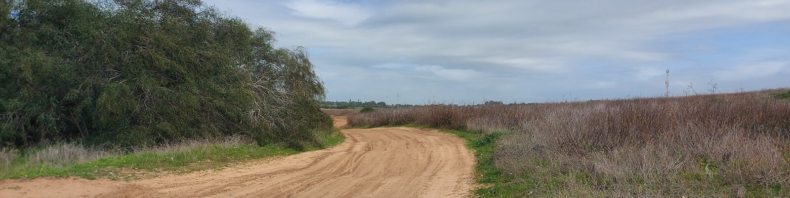
This day marks the third day of our journey along the coastline, where the vistas of the coastal cliffs are at their most stunning, undoubtedly captivating the pilgrims as well. From Givat Olga, we’ll proceed on the dirt paths skirting the Kurkar ridges for approximately 2 kilometers until reaching Mikhmoret. Then, we’ll navigate the main road, flanked on the east by settlement homes and to the west by a school and naval academy. This institution specializes in marine studies and boasts its own private harbor nestled within a picturesque bay. At the bay’s end lies an unexcavated archaeological site known as “Tel Girit.” However, the area is enclosed by fencing, necessitating a detour around it.
After passing the school, a trail known as the “end path” emerges among the eucalyptus trees to the west. This trail, crafted and marked by the boarding school students, veers off the sidewalk and through the sandy flora, leading back to the shoreline near where the Alexander River meets the sea. In summer, it’s possible to ford the stream by foot close to its estuary, provided you don’t mind getting your feet wet and walking barefoot on the sand. During winter, however, you must return to the road and use the bridge to cross.
Nahal Alexander is a sizeable river, flowing year-round much like Nahal Hadera, situated approximately 10 kilometers to its north. As we venture south, we transition from the Carmel coast’s region, characterized by smaller river drainage basins, into the Sharon plain, where the rivers originate in the Samaria mountains, resulting in significantly larger basins. Crossing these rivers in winter required bridges, even simple wooden ones, for carriages and sometimes for pedestrians. Moreover, these rivers often flooded the coastal plain, creating challenging swamps. A summer strategy involved trekking along the beach to cross the rivers at their shallow mouths, providing an opportunity to appreciate the wave views and beautiful sands along the way.
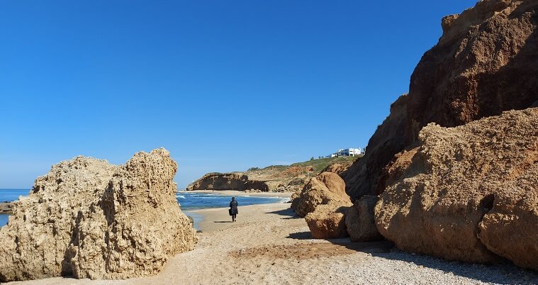
Rejoining the Israel Trail after crossing the Alexander River, we find that the trail markings might be sparse. However, guidance for reconnecting with the trail’s markers can be sought on websites like “Amud Anan” among others. The beachfront near Nahal Alexander is expansive, but as you head south towards Beit Yanai, you encounter the beginning of the coastal cliffs which progressively rise, reaching their zenith near Netanya. The stretch from Beit Yanai to Netanya is among the most picturesque segments of the coastal cliffs and shoreline, featuring bays, fallen boulders, and rocks in the sea teeming with crabs and minnows.
It’s advisable to walk beneath the cliffs, following the beach all the way to Herzl Beach, Netanya’s primary beach, which is lined with restaurants. From there, you can ascend to the cliff tops, standing 30 meters high, via the beach elevator, transitioning into the bustling urban environment. Then, the journey continues southward along the promenade of Netanya’s Cliffs, offering a blend of natural beauty and cityscape.
Netanya
Netanya, serving as the Sharon region’s capital, is a burgeoning city with a population exceeding 200,000. It’s recognized as a hub for the diamond trade. Prior to the War of Independence, the area that now encompasses the city was home to the Arab village of Umm Khalad (located near the Netanya interchange), where the remnants of a Crusader fortress constructed by Roger of Lombardy could be found. Although several walls of the citadel have withstood the test of time, they are not easily accessible for viewing. However, Netanya compensates with its stunning beaches, an array of hotels and restaurants, and a scenic promenade perched above the cliffs, offering breathtaking views of the sea.
Upon exiting the Herzl Beach elevator in central Netanya (with stairs available for those who prefer a climb), the journey continues southward along the magnificent cliff-top promenade. Navigating the coastline directly from this point becomes challenging, requiring a readiness to navigate water and rocks. The Israel Trail ascends here, leading to a broad and picturesque walkway known as the “cliff promenade.” The path eventually takes you to the Armed Forces Memorial and into the southern districts of Netanya, following the Israel Trail towards the enchanting “Dora” pond park. This park surrounds a beautiful seasonal winter lake nestled among the lofty residential areas of southern Netanya, offering a serene escape within the city’s dynamic environment.
Poleg Gate
Continuing from Poleg Beach, the journey follows the Poleg Stream and the Israel Trail eastward. To the south, the dunes beneath the Wingate Institute are visible, while the northern side is bordered by the neighborhoods of Netanya. However, the path, winding through lush vegetation, offers a sense of seclusion from urban proximity. The route through the Nahal Poleg Reserve, alongside a channel with water year-round, crosses beneath the coastal road, leading to the Udim Reserve.
Crossing under the coastal road into the Udim Reserve feels like stepping into a different realm, with the Wingate hills separating it from the sea. The trail meanders through a verdant valley beneath the rural homes of Udim and then ascends to an inner range of Kurkar hills. Here, the Romans carved a passage through the rock for the Poleg river, known as Shaar (Gate) of Poleg, designed to drain the swampy lands behind it. Climbing to the ridge south of the cut marks the transition from Udim Reserve to Shaar Poleg Reserve. The path continues along this ridge to the nearby Tel Poleg and the Yakum gas station and restaurant center, including a passage through Yakum Park. This segment of the trail offers a mix of historical insights, natural beauty, and the tranquil solitude of Israel’s coastal landscape.
Sharon Coast National Park
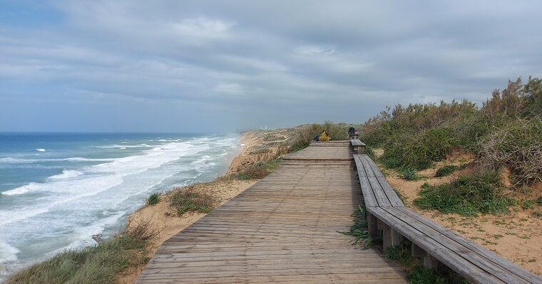
From Yakum Junction, the journey veers westward back towards the beach and the majestic cliffs that offer sweeping views of the sea. A pedestrian bridge facilitates crossing the coastal road, aligning with the Israel Trail as it meanders along the road atop the Kurkar Hills by the seaside. Skirting the perimeter of the Wingate Institute, the path reenters the enchanting landscapes of the Sharon coast, characterized by the tallest cliffs along Israel’s shoreline, interspersed with unique vegetation, sand dunes, and Kurkar formations. Approximately 2 kilometers onward, the entrance to Sharon Coast National Park is reached, featuring a trail that runs along the cliff edge, complete with stunning vistas, benches, and wooden lookouts.
The route continues south towards the area of Kibbutz Gaash, descending to the pristine Gaash beach, with a subsequent ascent 200 meters later. The effort to reach this white, immaculate beach is well rewarded. For overnight accommodations, there are two guest houses in Kibbutz Gaash or nearby Kibbutz Shefayim, recommended for a restful stop. For those seeking adventure, an overnight stay on the beach is an option, though continuing to the city of Herzliya is also viable, where numerous hotels are available. Alternatively, one can opt for a hotel in Netanya. Pilgrims on the “Via Palma” route historically aimed to traverse from Caesarea to Apollonia in a single day, possibly stopping at the fortress built by Roger of Lombardy in Netanya, or at farmhouses en route, for rest and respite.
The sixth day of our journey is predominantly spent in nature, traversing the cliffs above the sea and weaving through the city of Netanya. This stretch of the pilgrimage is marked by an absence of notable historical landmarks. Situated midway through the pilgrimage, this day lacks the initial excitement of the journey’s start and the first encounters with the sea, as well as the anticipation and elation of nearing its conclusion. However, this day is highlighted by the breathtaking views of the Israeli coastline and cliffs, reaching their zenith. At times, the stunning scenery might even make one feel as though they’ve stepped into a different country.
Day 7: From Apollonia to Jaffa
On the fourth day of our seaside trek, we approach the bustling metropolis of Tel Aviv, transitioning from the historic grandeur of medieval Jaffa. In those times, Jaffa was a crucial port city for the Land of Israel, serving as a pivotal arrival point for pilgrims and immigrants, whether coming directly from Europe or via Acre to avoid the lengthy overland journey.
The “Via Palma” pilgrimage can be conceptualized into three segments: physical, mental, and spiritual. The journey from Acre through Haifa and Carmel challenges the body, the coastal walk nurtures the mind, and the final stretch from Jaffa to Jerusalem is a spiritual ascent. As we conclude the coastal walk on this seventh day of the pilgrimage, we also close the chapter of mental preparation, readying ourselves for the spiritual journey ahead to Jerusalem. This transition evokes mixed emotions, blending anticipation for what lies ahead with a hint of melancholy for the seascapes we leave behind. The diminishing cliffs, gradually fading until they vanish within the Tel Aviv-Jaffa area, symbolize the end of our walk along the beach and the commencement of a new phase in our pilgrimage.
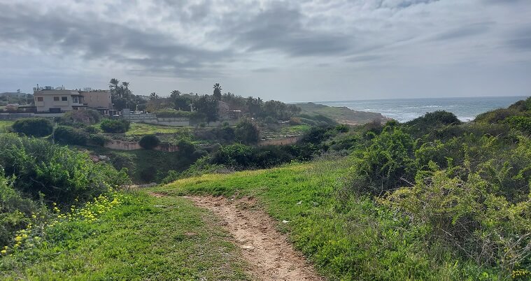
Departing in the morning from either Gaash or Shefayim, depending on where we chose to rest, our journey continues along the dirt paths running atop the cliffs. These cliffs, still among the most majestic along the coastline, lead us to another segment of the Sharon Coast Reserve and the areas just north of the Apollonia fortress and the Nof Yam neighborhood, home to a quaint ecological park.
Our path then takes us towards Sidna Ali Beach, and on to the citadel and remnants of the Crusader city of Apollonia, heralded as one of Israel’s most picturesque Crusader fortresses. Apollonia stands as a significant waypoint on the “Via Palma,” serving as a natural bridge between the pivotal hubs of Caesarea and Jaffa, and in a sense, intertwining with the broader pilgrim routes of Europe and the myths of the Holy Grail.
Apollonia
Apollonia traces its origins back to the Persian period (6th century BC) when it was established as a port city, originally named after the Phoenician sun god Reshef. Over time, Reshef became associated with the Greek sun god Apollo, leading to the various names Apollonia, Rishpon, or Arsuf. The city boasted a small harbor, natural defensive features, and fertile lands nearby. Legend has it that the Samaritans identified the tomb of the prophet Eli the priest in this location, a tradition that may have been passed down to Christian pilgrims and eventually adopted by Muslims in the form of Sidna Ali.
When the Crusaders arrived, Arsuf (Apollonia) stood as a Muslim fortress, willing to surrender only to Raymond of Saint-Gilles, a figure renowned for his generosity and integrity. His reputation ensured that his soldiers refrained from harming those who surrendered, including the inhabitants of Jerusalem under their protection. The Crusaders constructed a small city and an imposing fortress, now the focal point of the Apollonia National Park. Visitors are greeted by the remnants of the Citadel and the surrounding wall, along with structures, water cisterns, lime pits, and breathtaking vistas of the sea atop the cliffs.
The citadel stands as a masterpiece of fortification, boasting a deep moat on three land-facing sides, complemented by a wall adorned with five towers arranged in a semi-circular formation. On the western side, cliffs rise steeply towards the sea, enhancing the natural defenses. These towers oversee the moat and the fortified wall, offering mutual support. Rising behind the five towers is the imposing Keep Tower, octagonal in shape and fortified to ensure superior defense, commanding both protection and surveillance over the smaller towers. Spanning an area of 1,500 square meters, the citadel encompasses multiple floors, providing ample space for hundreds of knights. Below, a harbor lies under its control, likely linked by subterranean passages for strategic access.
The citadel’s significance extends beyond mere defensive prowess; it holds symbolic and mythical importance as well. Its design and dimensions hint at connections to the legends surrounding the Holy Grail. The deliberate choice of an octagonal Keep tower and the arrangement of five towers within the wall suggests a purposeful design, likely inspired by myth and legend. While the fortifications served practical defensive purposes, their unique configuration hints at deeper, symbolic meanings. Alternatives, such as the customary Castrum design found in other fortresses in Israel, could have been chosen, but John of Arsuf, the driving force behind the citadel’s construction, opted for a design rich in symbolic resonance.
John of Arsuf was the son of John of Ibelin, a prominent leader among the Crusaders who held senior positions in the Kingdom of Jerusalem during that period. Coinciding with the construction of the citadel, John of Arsuf collaborated and maintained correspondence with Richard of Cornwall, a renowned figure in England and the wealthiest man in Europe. Richard’s visit to the Holy Land saw him involved in the reconstruction of Ashkelon’s walls. His deep interest in the legends of King Arthur and the Holy Grail mirrored that of his uncle, Richard the Lionheart, who had previously visited Israel.
Richard of Cornwall, the grandson of Eleanor of Aquitaine and the son of King John, held significant titles including King of Germany and Earl of Cornwall. He played a crucial role in the Barons’ Crusade, a lesser-known but successful campaign spanning from 1239 to 1241. Initially led by Theobald of Champagne and Aubrey of Montfort, the latter phase of the crusade was led by Richard himself. This endeavor saw significant territorial gains in the Land of Israel, with some accounts suggesting Christian rule extended from the Mediterranean Sea to the Jordan River following its conclusion.
The legends of King Arthur and the Holy Grail emerged in Britain during the 12th century, particularly among individuals linked to the Templar order and the royal courts of Eleanor of Aquitaine and her daughter Marie of Champagne. These legends swiftly gained widespread influence, and figures like Richard of Cornwall, much like his predecessor King Richard the Lionheart, were immersed in them from a young age. It’s also believed that John of Arsuf was familiar with these legends. Interestingly, the castle at Apollonia bears a striking resemblance to Tintagel Castle in England, which was constructed by Richard of Cornwall around the same period.
Tintagel was traditionally believed to be the site where King Arthur was conceived, purportedly with the intervention of the wizard Merlin. Despite lacking significant strategic importance, Richard constructed a formidable fortress atop the cliffs overlooking Cornwall’s coastal cliffs. The architecture of the fortress incorporates elements from stories of the Round Table and the Holy Grail, including tales like that of Tristan and Isolde. Similar to Apollonia Citadel, Tintagel Citadel features a narrow entrance gate and is enveloped by cliffs towering tens of meters above the sea. Moreover, Apollonia stands out uniquely among Israel’s citadels as the waves crash against the cliffs at its base, a feature reminiscent of the setting of Tintagel Citadel.
Architectural elements within the Citadel of Apollonia suggest a connection to the legends of the Holy Grail. Its five towers bear a striking resemblance to those found in Caernarfon Castle in Wales, constructed with inspiration drawn from the Arthurian legends (albeit a bit later, in 1282, by Edward I), and echoing the towers and walls of the fabled Constantinople. The octagonal design of the Keep recalls the structure of Castel del Monte Castle in Apulia, Italy, commissioned by Emperor Frederick II around the same period. Frederick II, who also spent time in Israel, was known to be intrigued by the tales surrounding the Holy Grail.
At the onset of the 13th century, the Apollonia Citadel served as the focal point of a family domain. Melisinda of Arsuf, a member of this family, was initially wedded to Thierry d’Orca, a comrade of Henry II of Champagne and the son of Mary of Champagne. Growing up in the court of Mary of Champagne exposed Thierry to the earliest tales of the Holy Grail, as chronicled by Chrétien of Troyes.
It’s intriguing to observe that Henry of Champagne had dealings with the Assassins and was even invited to visit their stronghold at Alamut Castle; Thierry might have joined him on this occasion. This era was characterized by legendary knights and romantic heroes. Following Thierry’s passing, Melisinda of Arsuf inherited control of the castle in accordance with inheritance laws. She married John of Ibelin in 1207, thereby transferring the estate and citadel of Arsuf under the authority of the influential Ibelin family from Yavna, which held significant sway in the region. The son of Jhon of Iblin was John of arsuf – the Builder of Apollonia Castle.
John of Ibelin held considerable power as a local ruler in the Land of Israel at the start of the 13th century. He governed Beirut, acted as the aristocracy’s representative to the emperors, led the armies of Jerusalem and Cyprus, and served as regent of the kingdom. His marriage to Melisinda of Arsuf consolidated control over the Arsuf estate (seigneuria). They had several children renowned for their prowess as warriors and exemplary knights, akin to the Maccabees of old—military leaders and successful rulers who embodied the kingdom’s spirit. One of them was John of Arsuf.
Teitmer noted that the Ibelin family held sway over numerous fortresses in both Israel and Cyprus. Among these, Arsuf boasted the finest knights in the land. It served as a bastion of secular chivalry, with its knights tasked with safeguarding the pilgrim routes. In contrast, Atlit was the domain of the Knights Templar, warrior monks devoted to their cause, while Caesarea stood as a sizable city and administrative hub. Arsuf, on the other hand, epitomized secular romance and chivalry, likely hosting grand feasts within the fortress courtyard overlooking the sea.
The prevalence of bandits in the vicinity of Kfar Shmaryahu was indeed a driving factor behind the construction of the citadel, although it was not the sole reason for its impressive stature. Subsequently, Arsuf was transferred to the control of the Hospitallers, who governed the area from 1260 to 1265 until its capture by the Mamluks under Baybars. Its strategic location made it a significant stopover for pilgrims journeying through the region.
South of Apollonia
A short distance south of the Apollonia Citadel stands the Sidna Ali Mosque, an impressive square complex atop the cliffs, featuring a central courtyard and a revered tomb. Legend has it that Sidna Ali was a valiant Muslim warrior who battled the Crusaders in 1250. In the late 15th century, the Mamluks erected this complex in his honor, transforming it into an annual pilgrimage site for Muslims and Sufis from across the Land of Israel. Today, it remains an active mosque and a revered shrine, drawing visitors from far and wide.
Descending from the Sidna Ali Mosque leads us to the shoreline, where the Israel Trail follows the water’s edge. Continuing along the captivating Herzliya coastline brings us to Acadia Beach to the south, and from there, the trail guides us to the bustling marina docks—a hub of stylish entertainment. To the east, the cliffs are adorned with a line of upscale hotels and villas, while along the beachfront, various restaurants and swimming spots beckon. We now find ourselves in Israel’s wealthiest enclave, and as we proceed, the beaches will be accompanied by opulent hotels and clubs, with development growing denser as we approach Tel Aviv. Adjacent to the marina lies an ancient mound known as “Michal,” believed to have been a Canaanite and Phoenician city, suggesting that the marina area may have once been an ancient port..
At the boat beach south of the marina, we reconnect with the waterfront and continue our journey southward. The cliffs, though still picturesque, gradually diminish in height, leading us to the cliff beach near the Mandarin Hotel and the azure shoreline bordering what was once Tel Aviv’s Sde Dov Airport—a site now undergoing extensive and rapid development. Unbeknownst to us, we’ve reached the outskirts of Tel Aviv, evident by the transition to a paved path catering to both cyclists and pedestrians, bustling with crowds of people. The path winds gently along low hills flanking the beach, offering occasional glimpses of cliffs further ahead in Tel Aviv itself. Yet, for now, we bid farewell to the grandeur of Apollonia Cliffs, Hasharon Park, and Netanya Cliffs.
Here, the dominating skyline features the chimneys of the Reading Power Station, looming over the landscape with the towering structures of the bustling metropolis beyond. Just as the chimneys of the Hadera power station served as our northern landmark along the Carmel coast, we now have a new point of reference. The starkness of our technological society is laid bare by the imposing presence of the power plant’s massive edifices beneath the towering chimneys.
The picturesque promenade extends to the Yarkon estuary, where a lighthouse with an observation deck offers views stretching to the water’s edge. A bridge spanning the Yarkon River leads us to the Tel Aviv port complex, a popular destination for both daytime leisure and night entertainment. Here, the Israel Trail veers eastward, following the Yarkon River and its parkland to Tel Afek, known for the springs of the Yarkon River. From there, the trail heads south towards the Ben Shemen Forest.
At this juncture, travelers face a choice: to follow the traditional Crusader road to Jaffa, then onward to Ramla, or to bypass Tel Aviv by continuing along the Yarkon to Tel Afek, eventually reaching Lod and Ramla. Opting for the former entails traversing a densely urbanized area, primarily along asphalt roads. Regardless of the route chosen, a visit to Jaffa—a pivotal stop on the Via Palma pilgrimage route—is strongly recommended. Historically, many pilgrims arrived in Jaffa by boat from Acre or directly from Europe, embarking from there on the spiritual leg of the Via Palma towards Jerusalem—a journey spanning just two or three days.
Jaffa
Jaffa stands as one of the oldest cities in the world, adorned with the remnants of an Egyptian gate atop its hill. From the Greek myth of Andromeda and Perseus to the biblical tale of Jonah, Jaffa’s rich history intertwines with countless narratives. However, for the pilgrims of old, Jaffa held a distinct significance as the city where St. Peter sojourned in the house of Simon the tanner.
Legend recounts a remarkable event during St. Peter’s stay. Summoned to Jaffa upon the passing of a devout woman named Tabitha, St. Peter defied death’s grasp by commanding her to rise, and miraculously, she did. Following this awe-inspiring event, St. Peter lodged in the abode of Simon the tanner, where he experienced a divine vision. In the vision, St. Peter, beset by hunger, beheld an angel bearing a platter laden with assorted seafood, including shrimp and calamari—fare not deemed kosher. Yet, the angel reassured St. Peter, declaring that what God has sanctified cannot be deemed impure. This moment became pivotal in Christian theology, signifying the acceptance of non-kosher foods and the inclusion of non-Jewish individuals into the burgeoning Christian community.
The day prior, an angel had appeared before Cornelius, a Roman army officer stationed in Caesarea, instructing him to dispatch messengers to Jaffa and summon St. Peter. As St. Peter concluded his vision concerning the seafood, there came a knock at the door of the house where he lodged. The messengers bore an invitation from Cornelius to journey to Caesarea. Recognizing the divine will expressed in his vision—that religion was to be open to all—St. Peter readily acquiesced and accompanied them (Acts of the Apostles, 10:1-17). The narratives surrounding Cornelius and St. Peter imbued pilgrims’ visits to Jaffa with profound emotional resonance, linking their experiences in Caesarea two days prior with their time in Jaffa.
Besides St. Peter, Jaffa held significance for pilgrims in its connection to St. James, the patron saint of Europe, whose relics were enshrined in Santiago de Compostela. According to accounts in “Journeys of the Holy Pilgrims,” prior to their arrival in Santiago, the saint’s remains were purportedly placed on a stone in Jaffa. Miraculously, this stone, along with the body without its head (which remained for unknown reasons at the Church of St. Jacob in the Armenian Quarter of Jerusalem), embarked on a sea voyage to Spain. Eventually, the body reached Santiago de Compostela, transforming it into Europe’s foremost pilgrimage destination. The stone likely found its way back to Jaffa, as it was reportedly displayed on a pier in the harbor known as “St. Jacob’s Pier,” establishing a tangible link between two of the Middle Ages’ significant pilgrim routes: the Camino de Santiago and the Via Palma (the third being the Via Francigena, leading to Rome).
In the mid-13th century, Louis IX oversaw the reconstruction of Jaffa’s city walls and the establishment of a Franciscan monastery, effectively dividing Jaffa into two distinct areas: the upper city, housing the fortress, and the lower city near the port. Within the fortress area, a church dedicated to St. Peter and prayer houses were erected. Today, St. Peter’s Franciscan Catholic Church stands beneath the hill of Jaffa, occupying the site traditionally associated with the house of Simon the tanner where Peter resided. However, there are differing opinions regarding this identification. Armenians, for instance, believe that Simon the Tanner’s house was located elsewhere near the harbor, while the Russian Orthodox claim it is situated at the Russian Church of St. Peter in Abu Kabir.
The Franciscan church underwent reconstruction in the late 19th century, adopting a Baroque style with generous support from the Spanish royal family. Renowned as one of the most exquisite churches in the country, it possesses distinctive architectural features. Unlike conventional churches, its entrance lies to the east while the apse faces west. This arrangement aligns with the tradition of pilgrimage churches, constructed at sites associated with events recounted in the New Testament, thereby transcending conventional architectural norms. Within the apse, a depiction of the pivotal event unfolds: the angel appearing to Peter in a dream, bearing a cloth handkerchief containing a diverse array of animals, among them reptiles and sea creatures, deemed impure according to Jewish kosher laws. The angel’s message to Peter, permitting him to consume these creatures, including the fried shrimp and calamari abundant in the nearby port of Jaffa, signifies the universality of the gospel, extending beyond the confines of Judaism..
The stained glass windows within the church feature depictions of esteemed Spanish saints, notably Teresa of Avila. Delicate paintings and intricate wood carvings adorning the preacher’s stand narrate pivotal events from the lives of Peter, Jesus, and Mary. These artistic renderings unveil the devout adherence to Mariological doctrines by the church’s constructors, evident in representations of the Immaculate Conception and a depiction of one of her apparitions in Czestochowa, Poland. Adjacent to the church stands a modest monastery building, which showcases remnants of the Crusader fortress that once occupied the site during the era of Louis IX.
Below the monastery, along the waterfront street leading to the port of Jaffa, lies the Saint Nicholas Monastery, now under the stewardship of the Armenians and affiliated with the Armenian Brotherhood of the Holy Sepulchre. The monastery boasts spacious cruciform halls surrounding a balcony that offers panoramic views of the sea, adorned with a khachkar, a traditional Armenian stone cross. Another revered Christian site among Armenians is a dwelling situated above the port itself, nestled beneath the lighthouse, which they identify as the house of Simon the Tanner. Additionally, Jaffa hosts other churches belonging to diverse Christian denominations, including the Maronites, Copts, and Greek Orthodox. Just a short distance from Jaffa hill stands the Greek Orthodox Church of St. George, erected at the close of the 19th century.
A tour of Jaffa typically commences at St. Peter’s Catholic Church, then progresses to the port area and the Armenian churches, followed by a leisurely exploration of the labyrinthine alleys of the old city and the scenic public garden atop the hill. Continuing onward, visitors can meander through the streets of Arab Jaffa. Along Yefet Street, Jaffa’s main thoroughfare, stands the grand St. Anthony of Padua Church, constructed in 1930 and serving as the city’s primary Catholic church. Managed by the Franciscans, the church is accompanied by the Franciscan school and monastery. St. Anthony of Padua, renowned for his eloquence and erudition, was a cherished disciple of St. Francis and entrusted with the educational duties of the order, thus earning him recognition as patron saint of educational institutes.