This is a rudimentary translation of articles from my book “Goddess Culture in Israel“. While it is far from ideal, it serves a purpose given the significance of the topic and the distinctiveness of the information contained. I have chosen to publish it in its current state, with the hope that a more refined translation will be available in the future.
The largest Stone Circle in the World
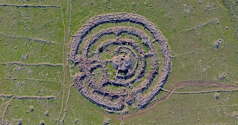
While Stonehenge in England is widely renowned, lesser-known is the fact that Rujum Hiri in the Golan Heights is considered the largest and oldest stone circle globally. This vast stone structure, situated in the heart of the Golan Heights near Gamla, forms an impressive stone wheel. Previously believed to date back to the Early Bronze Age, recent research attributes its origins to the third and final phase of the Goddess culture, specifically the Chalcolithic period. In contemporary times, Rujum Hiri has evolved into a pilgrimage destination for individuals associated with the “New Age” movement. Many visitors report experiencing a sense of energy and connectivity while at the site, sometimes receiving messages or insights during their visits.
The dimensions of Rujum Hiri are truly remarkable: its outer circle boasts a diameter of 156 meters, with a circumference nearing 500 meters. The outer walls stand at an impressive height of 2 meters, although they were once twice as tall. Notably, the site features two openings—one facing northeast, toward the sunrise on the longest day of the year, and the other southeast, aligned with the sunrise on the shortest day. Positioned directly eastward are two larger stones, distinguishing themselves from the rest, through which the sun rises during the equinoxes in autumn and spring. Additionally, there’s a smaller opening—a sort of passage—located on the southwest side, oriented toward the sunset on the shortest day of the year.
Within the wheel structure, there are three complete stone circles and two semi-circles, constructed primarily from large heaps of unrefined field stones, although some appear to have been chiseled. At the center of the circle lies a substantial mound of stones known as Rujum, measuring over 20 meters in diameter and once towering to a height of 8 meters. Inside this mound, there is a chamber with an access corridor. The total weight of the stones within the entire complex amounts to approximately 40,000 tons, and it is estimated that the construction of the wheel necessitated around 120,000 workdays.
Freikman, who conducted excavations at the site, asserts that prior to the construction of Rujum, there existed an earlier stone circle measuring 100 meters in diameter to the southwest. This circle comprised approximately 10,000 tons of stone. However, it was dismantled to facilitate the construction of the current stone circle—a practice commonly observed in ancient sanctuaries. The utilization of building blocks from the earlier sanctuary underscores the continuity of Religious tradition. Freikman proposes the existence of a paradigm of rituals and sanctity passed down through generations, which remains to be fully deciphered. Upon examination, he noted a conspicuous absence of archaeological findings within a 400-meter radius surrounding the stone circle—a phenomenon suggestive of a sort of taboo associated with this area.
Until recently, it was believed that the construction of the stone circle took place during the Bronze Age. However, the realization that worker camps or villages would have been necessary nearby, accommodating a sufficient number of people to undertake the construction work and return home each day, challenges this assumption. According to Freikman, the most suitable period for such activities is the Chalcolithic era. During this time, there were approximately 50 settlements located within a 5-kilometer radius of Rujum, housing over 2,000 inhabitants collectively. Additionally, hundreds of other settlements were scattered throughout the nearby Golan Heights and Jordan Valley. Through archaeological findings and sediment analysis, Freikman demonstrated that Rujum had already been in existence during the 5th millennium BC, during the era of the Goddess. It served as a sacred site for thousands of years, emerging as a spiritual center of the Golan region.
In 2006, Freikman conducted a survey of the Rujum area and made a significant discovery. At a distance of 400 meters from Rujum—beyond the area deemed taboo—he identified several large sites dating back to the Chalcolithic period. These sites encircled Rujum in a semicircular formation, spanning from the north to the east. Among the findings at these sites were large houses, a type previously unseen in the Golan region. These houses featured spaces designated for various crafts and activities, expansive courtyards, and structures resembling warehouses. Remarkably, the architectural style of these houses bore a striking resemblance to those found in large agricultural villages from the ceramic period of the Goddess, such as Shaar Hagolan.
Besides the circle of settlements and houses encircling the stone circle from a distance, the area between these settlements contains fields of Megalithic tombs of two distinct types. One type appears simpler and likely dates back to the early Bronze Age, while the second type, more intricate in design, hails from the final phase of the Goddess era, specifically the Chalcolithic period. These complex tombs, known as Dolmens, are adorned with stone piles arranged to form tumuli, reminiscent of the central mound within Rujum.
Freikman challenges previous archaeological assumptions by asserting that the large mound at the center of Rujum indeed dates back to the time of the Goddess, constituting an integral part of the structure. The tumuli in the vicinity of Rujum appear to mimic its design, further bolstering this argument.
Freikman identifies three larger geographical circles surrounding the stone circle, each corresponding to spheres of influence related to the holy fire. While Freikman’s categorization into three spheres aligns with Landscape Archaeology theories, it also resonates with Rappengluck’s descriptions of distinct areas bearing varied influences around the Holy Fire.
The first circle, akin to the immediate vicinity around the fire, was considered taboo and potentially perilous to enter, encompassing the entire area within a 400-meter radius of the Rujum deliberately left vacant. The second circle denotes the sphere of activity and vitality, housing sizable settlements with intricately designed houses interspersed with numerous tumuli and dolmens. Here, the living coexisted with the deceased, perceived as also being alive albeit in a different form. This region parallels the zones around the fire where human activities thrive, benefiting from its warmth and illumination. Positioned within sight but at a safe distance, this settlements circle is influenced by its proximity yet shielded from potential harm. The third circle encompasses sites visible from afar, such as Mount Farass to the northeast, symbolizing the spiritual essence of fire, transitioning from the palpable heat felt up close to the radiant light observed from a distance.
According to Freikman, the apertures within the wheel are oriented not only towards the sunrise and sunset but also towards significant landmarks in the landscape: the northeast opening aligns with Mount Farass, while the southeast opening faces Tel Saki. Additionally, the smaller opening in the southwest is directed towards Mount Tabor, and so forth. These elevated sites on the horizon (consisting the third outer circle) likely served as gateways to the otherworld, facilitating communication with the spirits of ancestors. Freikman suggests the possibility of Megaliths once occupying the summits of Mount Farass and Tel Saki.
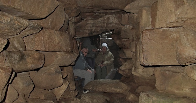
According to Freikman, the tumulus featuring a chamber at the center of the wheel served various purposes such as shamanic rites of passage and communication with ancestral spirits. In the past, there was an additional small opening above the room’s entrance that allowed light to enter on specific days of the year, symbolizing the cosmic cycle of death and rebirth. He posits that during the Chalcolithic period, a Religious revolution occurred, emphasizing the connection with the realm of the dead and the pursuit of eternal life. This led to the development of a complex belief system and rituals that became central to both private and public life. In this context, the construction of Rujum Hiri as a site for rites of passage and communication between the living and the dead is comprehensible, without negating its other functions as an astronomical observatory and time calendar.
Yonatan Mizrahi from Tel Aviv University and Anthony Avni from Colgate University in New York conducted research on the celestial and terrestrial orientations of Rujum Hiri. They found that Mount Hermon stands directly north of the center of the circle, while Mount Tabor aligns with the direction of sunset on the longest day of the year. These two mountains were highly revered by the ancients in the northern region, appearing together in biblical texts as “The Great Hermon” and “The Little Hermon.” Therefore, they propose that there was a deliberate orientation towards prominent landscape features.
Moreover, among the 36 walls connecting laterally between the different circles of the stone circle, they discovered that 22 are oriented towards the sunrise or sunset of 22 of the brightest stars in the sky, including significant star systems such as Orion or Sirius. This observation, combined with the alignments of the openings towards sunrise and sunset on the longest day, the shortest day, and the equinox, led them to conclude that the stone circle served as a sophisticated observatory and a calendar for the year’s agricultural activities. Given that most of the rain and agricultural work in Israel occurs between the autumnal equinox and the spring equinox, this interpretation underscores the practical significance of the site.
Mizrahi and Avni’s research revealed that the builders of the site employed a consistent unit of measurement, likely of a Sacred nature, measuring 4.70 meters in length. All measurements within the site correspond to this unit, reminiscent of the Megalithic yard used in sites from the era of the Goddess culture in England. However, the significance of this particular measure remains unclear.
Contrary to Freikman’s perspective, Mizrahi and Avni argued that the construction of the giant tumulus in the center of the wheel occurred during a later period. Their research revealed the presence of a hidden pyramid shape within the mound, composed of large basalt stones, although the reason for this configuration remains unclear. They noted that the circles were measured from the center rather than in relation to each other. Interestingly, they found that the center from which the circles were measured was not where the burial chamber stands today, but rather 4 meters to the south of it. This suggests, according to their interpretation, that the circles were initially constructed, with the large stone mound and burial chamber added at a later stage.
Mizrahi and Avni proposed that the primary ceremonies conducted at the site centered around the entrance of sunlight through the northeast opening on the longest day of the year, and its setting on Mount Tabor during the shortest day. They theorized that Sacred marriage rituals took place within the Rujum to ensure fertility for the land, humans, and animals. Additionally, they suggested that the stone circle functioned as an agricultural calendar, signaling the onset and cessation of rains and the beginning of agricultural seasons through the positioning of the sun between the two prominent stones marking the equinoxes. However, they acknowledged that such a large structure may not have been necessary for this purpose, considering other indicators such as the blooming of flowers.
In my view, the researchers overlooked the religious and spiritual significance that ancient sacred sites held. According to Rappengluk, the North Star symbolized the axis of the world and the potential for achieving eternal life. Mount Hermon, situated just north of Rujum, aligns with the North Star, a connection further emphasized by the positioning of several of the Golan’s volcanic mountains along this axis. Notably, the most prominent extinct volcanoes in the Golan, including Mount Avital, Bental, Mount Hermonit, and Mount Varda, form an exact north-south alignment from Rujum Hiri to the striking Mount Hermon. This alignment corresponds to the movement of the star systems observed in the connecting walls of the stone circle. The orientation toward Mount Hermon at the precise north echoes the celestial dynamics of the sky. Consequently, there are more connecting walls on the eastern side of the circle, aligning with the direction of starrise. Additionally, the inner semicircles within the stone circle likely face south. While this topic warrants further exploration, it is undeniable that the presence of Israel’s highest and most prominent mountain due north of Rujum Hiri held significant importance.
Rujum Hiri is accessible via a brief half-hour walk from the main road of the Golan, along a dirt road heading east just before the turn to the Gamla Nature Reserve. Alternatively, visitors can opt to hike along the Golan path from the Daliot parking lot. To reach the site safely, it is advisable to bring along a map and consult with someone familiar with the route.
Around the stone circle, numerous tumuli, dolmens, and remains of settlements from the Chalcolithic period dot the landscape. Notably, about 1,500-2,000 meters south of Rujum Hiri, in the vicinity of Hurvat el Ramlit, there exists a remarkable concentration of dolmens and tumuli. This area comprises a vast burial ground characterized by large tumuli, dolmens, and mounds of stones, arranged in a semi-circle around a low, flat assembly area. Some of these tumuli and stone mounds contain interior chambers, with one of them revealing drawings of a ladder on the ceiling, possibly representing a chronological sequence.
About 500-1,000 meters north of Rujum, situated on a ridge overlooking it, lies a remarkable concentration of tumuli. Among them, the easternmost one stands out for its size, resembling a mound and mirroring the dimensions of the central mound within the stone circle. Within this tumulus, a sizable chamber was unearthed, accessible via an entrance corridor from the east, akin to the room inside the central mound of Rujum. Strikingly, the heights of the two mounds (inside the circle and on the ridge) are identical. Metaphorically speaking, if one represents the sun (at the heart of Rujum), the other could symbolize the moon (on the ridge — the horizon). Additionally, other tumuli along the ridge also feature chambers and spaces, with traces of a house discovered and excavated by Freikman in between them. Exploring this ridge, through which the Golan Trail passes, complements a visit to Rujum Hiri.
Stone Circles in Israel
If one stone circle exists, such as Rujum Hiri, it’s reasonable to assume the presence of others, akin to those found in Britain, particularly if we accept the notion that stone circles reflect religious beliefs. Indeed, evidence and remnants of additional stone circles have been discovered in Israel. However, it’s important to note that stone circles in our region typically consist of piles of stones, forming circular walls or terraces, rather than single giant stones like those found in Stonehenge or Avebury. Consequently, identifying them can be challenging.
According to Freikman, in the Golan, there are two other stone circles similar to Rujum Hiri from that period. One of them is Hurvat Buţayḩah, a substantial Megalithic site situated on the bank of the Jordan River north of Bethsaida. The site comprises three circular concentric walls, with a large pile of stones at the center under which lies the Dolmen burial chamber. The outer circle has a diameter of 56 meters and features an opening that, like Rujum Hiri, faces towards a prominent nearby mountain summit adorned with several Dolmens.
Another site recently discovered during the Golan survey was given the inspiring name – Site 133. Situated 11.5 km east of Qatsrin and a few kilometers north of the waterfalls junction, it sits atop a hill overlooking the Nahal Zavitan canyon. According to Freikman, the site comprises a central chamber surrounded by concentric circular walls, with the outer circle reaching a diameter of about 52 meters. Freikman notes that all three sites in the Golan are situated near water sources, and their outer circle dimensions are multiples of a number close to 50 meters. In essence, there are two additional stone circles in the Golan Heights, each about one-third the size of Rujum Hiri.
In addition to these circles, above Kibbutz Parod lies a cairn of stones shaped like a huge semicircle called Gal Jethro (Rujum en-Nabi Shu’ayb), while below the Sea of Galilee, there is a massive cairn of stones shaped like a cone. On the western side of Israel is the small stone circle of Atlit Yam, dating back 8,000 years, which is currently underwater. Furthermore, testimonies from travelers to Israel in the 19th century reveal the existence of a circle of megalithic stones beneath the summit of the Muharka (the Horn of Carmel), which has since been destroyed and disappeared. Father Eli Friedman suggested that it dated back to the Chalcolithic period.
In Jordan, numerous stone circles have been discovered, including those at the Murayghat Hajr al Mansub site near Madaba. At this location, remnants of large single stone circles from the Chalcolithic period, as well as Menhirs and a field of dolmens, have been found. Australian archaeologist David Kennedy, renowned for his expertise in aerial photography, identified eight enormous circles composed of low walls with diameters ranging from 250 to 500 meters. These circles are scattered across the highlands of Trans Jordan, extending from the Moab plateau in central Jordan to the Edom Mountains and Wadi Rum in the south. Some of them exhibit geometric perfection. Moreover, several giant low wall stone circles have been unearthed in eastern Jordan and even in the Homs region of Syria.
One of the remarkable discoveries in recent years has been the identification of thousands—yes, thousands—of stone circles in eastern Jordan, situated in the desert region of Azraq. These circles typically exhibit diameters ranging from approximately 25 to 75 meters and are predominantly found in basaltic areas, displaying various shapes. What’s astonishing is that these low wall stone circles are only discernible from an aerial perspective; on the ground, they are challenging to detect. Typically, they manifest as circles with spokes formed by arranged stones visible on the surface.
Across the globe, there exist formations on the earth’s surface that are visible only from an aerial vantage point, much like the famed Nazca Lines in Peru. Termed as geoglyphs, these are large symbols of artificial origin etched onto the earth. Such formations have fueled arguments by authors like Erich von Daniken (“Chariots of the Gods”) who suggest that in ancient times, Earth was visited by UFOs. The rationale behind this argument lies in the fact that these shapes hold significance only when viewed from above, presumably from a manned aircraft. It’s noteworthy that Jordan boasts geoglyphs that are equally impressive in quantity, size, and shape as the Nazca Lines, and remarkably, they predate them by a considerable margin.
Stone circles indeed represent a global phenomenon, spanning across various regions including England, France, Spain, Ireland, Scotland, Armenia, the Caucasus, and the Balkans. Notably, while Stonehenge, for instance, dates back approximately 4,000 years, stone circles in Israel, exemplified by Rujum Hiri, predate them by at least 2,000 years. Despite this significant temporal gap, the stone circles in Israel are equally captivating and serve as a testament to the rich and diverse cultural heritage of the region.

Dolmens in the Golan Kibbutz Shamir
Archaeologists estimate that there are approximately 6,000 Dolmens scattered across Israel, with likely even more in ancient times. The Golan Heights boast the largest concentration, followed by significant numbers in the Korazim Heights, around the Hula Valley, and smaller clusters in the Galilee. Additionally, individual Dolmens can be found throughout the country, spanning from the lowlands to Samaria and the Judean Mountains. Some argue that the Tumuli in the Negev could be considered a form of Dolmen as well.
Archaeologists hold differing views regarding the dating of the Dolmens, but a prevailing opinion suggests they were constructed during the early to middle Bronze Age, approximately 4,000 to 5,000 years ago. These structures are commonly interpreted as burial sites built by nomadic tribes during a period of decreased urbanization in the region. However, recent research challenges this perspective. While artifacts, ceramics, and burial remnants dating back to the Middle Bronze Age have been discovered within Dolmens, evidence suggests that these structures are much older. It appears that the Dolmens predate the burials found within them, indicating that the stone formations might have served a different purpose before being repurposed for burial.
There are various types of Dolmens, with some, like those at Kibbutz Shamir, featuring larger spaces than necessary for human burial. These expansive interiors hint that Dolmens may have served purposes beyond mere burial sites. Some scholars suggest they may have been locations for initiation rites and passage to the afterlife, as discussed in previous chapters on Dolmens and their sanctity. This interpretation does not negate the presence of burials within these structures; rather, it suggests a potential intertwining of these practices. The bones of the deceased brought a sense of mana and sanctity to the surrounding life processes. In other countries, such as Wales, evidence indicates that bones, particularly skulls, interred within Dolmens were occasionally removed. It is theorized that these bones may have been placed atop the Dolmens during specific celestial events to absorb solar or stellar energies. The inclusion of these sacred relics within the Dolmens contributed to their unique atmosphere, drawing devotees seeking communion with the spiritual energies believed to reside there.
Dolmens represent a global phenomenon, emerging for the first time around 6,000-7,000 years ago in Western Europe, the Caucasus, and the Middle East simultaneously. It is improbable that disparate societies independently conceived of constructing such similar structures without some common influence. This suggests the presence of a widespread religious and cultural belief system that revered Dolmens during that era. Their cessation in construction across the world around the same period further supports the notion of a shared cultural shift or the end of a common religious practice.
Various typological forms of Dolmens recur across different regions of the world. One notable example is Dolmens featuring a small square opening carved into a flat stone that closes on one side, resembling an aperture in a box. These structures are found in the Caucasus, Bulgaria, and even in Jordan (near Tel Damiya). The consistent presence of this distinctive shape across distant locations prompts questions about how such a specific architectural style emerged simultaneously in various regions. It suggests the possibility of cultural exchange or transmission of knowledge, perhaps by itinerant figures such as priests or shamans who disseminated the construction techniques for sacred structures. This phenomenon mirrors the construction of churches globally today, which often adhere to similar architectural patterns rooted in religious concepts.
In an article by Prof. Gonen Sharon [2], a renowned expert on Dolmens, he contends that the Dolmens located south of the Yarmuk River in Trans Jordan date back more than 5,000 years, whereas those north of the Yarmouk River, in the Golan Heights and the Hula Valley, are approximately 4,000 years old. The significant age gap between the Dolmens on opposite sides of the river, spanning over a thousand years, raises puzzling questions. This disparity appears illogical and requires further investigation to elucidate the reasons behind it.
Friekman, in his doctoral thesis on the Megaliths in the Golan under the guidance of Prof. Yosef Garfinkel, posits that the majority of Dolmens in Israel date back 6,000 years or more, originating from the era of the Goddess. Contrary to previous studies that focused on artifacts within the burial chambers, Friekman’s excavation and analysis of the structures and their environs, including sediment tests, revealed their Chalcolithic origins. I tend to agree with Friekman analysis and to dismiss the conclusions of Gonen Sharon
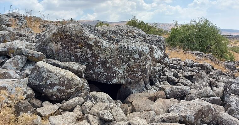
In excavations led by Claire Epstein in the settlement of Rasem Harbush, near Rujum Hiri, Dolmens were found adjacent to houses dating from the Goddess era. Despite Epstein’s conclusion that the Dolmens were from a later period, Friekman holds the opposite view. He argues that during the Goddess era, people buried their dead either inside or near their homes, citing numerous instances of Dolmens attached to houses in the Golan Heights, totaling over 90. This, according to Friekman, cannot be mere coincidence and suggests that the Dolmens and Chalcolithic settlements in the Golan were contemporaneous. Additionally, one of the most significant clusters of large Dolmens, dubbed the “Stonehenge of Jordan,” near Midba at Murayghat Hajr al Mansub, is believed by site researchers to date back to the Chalcolithic period.
In Israel, there are notable fields of Dolmens easily accessible to visitors. Near Gamla, inside the national park, there is an impressive Dolmen field, part of which is regulated for exploration. Close to Kibbutz Shamir, the “Dolmen Trail” leads to the largest Dolmen in Israel. This tumulus, with a diameter of 20 meters, overlooks the Hula Valley from the east and contains four burial chambers. The largest chamber is a spacious Dolmen, akin to a room (rather than a grave), allowing visitors to stand inside. It is covered with a massive stone weighing 50 tons. Engravings resembling a pitchfork were discovered on the ceiling. Although archaeologists are unsure of its significance, those knowledgeable in astronomy recognize the pattern as resembling the orbit of the star Sirius A, the brightest star in the sky, alongside its companion Sirius B. This shape is reminiscent of the depictions found in “The Mystery of Sirius” by Prof. Robert K. G. Temple, which discusses the Dogon tribe in Mali, Africa. Temple suggests that the advanced astronomical knowledge depicted in their wall paintings indicates exposure to visitors from outer space originating from the Sirius star system.
Even if Temple’s claims are dismissed as unsubstantiated by many, and even if the painting on the ceiling of the Dolman in Shamir bears no relation to the artwork of the Dogon tribe, it is not unreasonable to consider that the paintings may have represented celestial phenomena or the movement of stars in the sky in some form.
More wall paintings have recently been discovered in various Dolmens throughout the country. For instance, near the hexagon pool in the Golan, there is a large Dolmen adorned with paintings depicting animals and geometric shapes. On one side of the inner room, six horned animals, possibly ibexes or deer, are depicted, while the other wall features geometric patterns such as square grids and a depiction of a single horned animal. In ancient cultures, horns were often associated with the moon, as discussed in previous chapters, suggesting that the Dolmen was intentionally designed to harness the energy of the moon and stars.
Dolmens are often found in clusters, leading some to suggest that their arrangement may represent star systems, with the positioning of Dolmens on the earth resembling a celestial map. Furthermore, some Dolmens feature small cups engraved on their roofs (the upper part of the casing rock), which could potentially represent star systems as well.
Gal Jethro
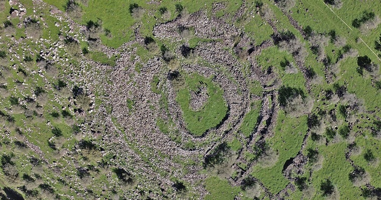
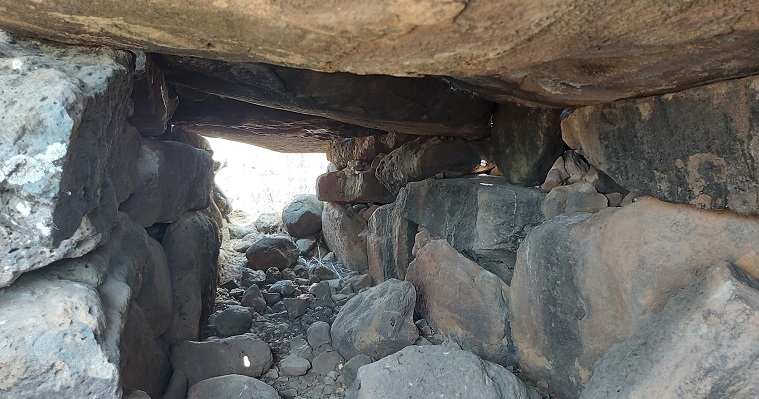
On the slopes of Mount Meron lies one of Israel’s largest and most impressive megalithic sites—a massive semicircle of gathered stones, forming a cairn measuring 150 meters in length, 20 meters in width, and 7 meters in height. This giant cairn comprises 14,000 cubic meters of stone, similar to Rujum Hiri, which contains “only” 13,000 cubic meters of stone.
The site, researched by Ido Wachtel and recently discovered, poses challenges in access, with paths being unregulated and difficult. Situated several tens of meters above the springs of Parod and a few hundred meters from the settlement of Parod, its builders and purpose remain unclear. Wachtel leans towards associating it with the Bronze Age, dating back 5,000 years ago, although there are indications suggesting it may be even older.
During the Chalcolithic period, the area witnessed significant settlement, with discoveries made in nearby Peki’in. Sites resembling Gal Jethro in the Golan Heights were dated by Michael Freikman to the Chalcolithic period. If Rujum Hiri is indeed from that time, as Freikman asserts, then it stands to reason that Gal Jethro also dates back to this period.
If we apply the concept of Landscape Theory to Gal Jethro, it aligns with Mount Karnei Hittin to the south, named for its double summit resembling horns. Karnei Hittin, an extinct volcano south of the Arbel valley, has remnants of an ancient settlement atop it. Gal Jethro is oriented so that its opening faces this mountain. In modern times, Druze residents of surrounding villages would ascend the cairn to gain a clear view of the tomb of Nabi Shuaib, sacred to them and situated at the base of the Horns of Hittin. This association led to the cairn being named Rujum en-Nabi Shu’ayb, after Shuaib, who is identified as Jethro, the father-in-law of Moses, or Gal Jethro.
On the flip side, Gal Jethro is aligned with Mount Meron behind it. Mount Meron boasts a double summit and stands as the tallest mountain in the Galilee. Such typological features were considered sacred to ancient cultures, suggesting that the semicircle of Gal Jethro might have mirrored the crescent shape of Mount Meron.
The intriguing aspect is that if you draw a straight line connecting the summit of Karnei Hittin with that of Mount Meron, it passes directly through the center of Gal Jethro. Whether this is merely a coincidence or a deliberate intention remains uncertain. However, if it’s not happenstance, it suggests a purposeful endeavor to link two sacred mountains with double peaks by constructing a cairn of stones in a similar shape (a semicircle with two horns), possibly to amplify the energy of these two mountains.
The other intriguing orientation of Gal Jethro is that if you draw a straight line connecting it with Gamla in the Golan, a significant location in Chalcolithic times and the starting point of the Dolmen field extending to Rujum Hiri, the line precisely intersects the middle of the Butayhah stone circle. This is another “coincidence” that suggests the possibility of a master plan behind all the megalithic sites.
If we stand on the western side of the cairn of stones and observe where the western horn points, we will encounter more “coincidences.” In front of us lies the hill of ancient Galilean Beer Sheva, near Kefar Hanania. This area was among the first places in the world where pottery emerged, owing to its fine clay. Consequently, pottery workshops flourished there in ancient times, renowned for their quality, up to the Roman era. It’s plausible that the Jethro cairn was constructed as a tribute to Mother Earth for the gift of ceramics.
Moreover, in the vicinity of Gal Jethro are the Parod Waterfalls, a magnificent natural spectacle where water cascades over calcite rocks. These rocks, covered with chalk that dissolves in water, resemble stalactites and stalagmites found in caves, and were considered sacred by ancient cultures. There are no other waterfalls like the Parod Falls elsewhere in the country, which may explain why the cairn of stones was erected in this particular location. Freikman demonstrated that all the stone circles in the Golan were constructed near water sources, and this holds true for Gal Jethro as well.
Gal Jethro’s site has not undergone extensive excavation, and aside from a few potsherds (which might be from a later period), no significant findings have been uncovered. However, there is a sense that hidden chambers lie within, and it may still conceal its secrets. Only time will reveal the truth.

Pyramid under the Sea of Galilee
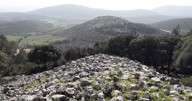
About a kilometer north of the Ohalo site, approximately 100 meters from the shore of the Sea of Galilee, lies one of the most remarkable and largest megalithic structures from the time of the Goddess, recently discovered submerged in the water. It takes the form of a massive stone cone with a diameter of 70 meters and reaching a height of 10 meters, comprising around 60,000 tons of basalt rocks, some as large as a meter in size, transported from a distance. For comparison, Rujum Hiri consists of 40,000 tons of stone. The peak of this colossal structure lies submerged 2-3 meters underwater and can be observed from a boat. Although the exact purpose and builders of this superstructure remain unknown, its construction undoubtedly required an immense amount of labor.
Various archaeologists have attempted to date the monument. Michael Freikman made a significant discovery regarding the base of the stone cone, which is covered by 2 meters of fine sediment. Through calculations based on the rate of silt deposition in the lake over time, he estimated that the span during which such an accumulation of sediment could occur ranges from 4,500 to 9,000 years. Freikman suggests that the giant cone is approximately 4,500 years old, coinciding with the existence of the ancient city of Beit Yerah on the lake’s shores during the early Bronze Age. He speculates that the construction of the cone may have been related to the city’s inhabitants’ efforts to prevent the Jordan River’s exit from being blocked north of them. However, some question this theory, as it would have seemingly been more straightforward to dig a channel to address the issue rather than construct such a massive monument.
Other archaeologists have put forth the idea that the construction of the giant cone dates back to the early Bronze Age, marking the dawn of recorded history approximately 5,000 years ago. This suggestion aligns with one of the suggested timeline for the construction of other megalithic sites of similar scale, such as Rujum Hiri and Gal Jethro, which are in close proximity. Additionally, the presence of the city of Beit Yerah during this period could have provided the necessary labor force and motivation required to build such a massive and impressive structure. Settlements of comparable size were not known to exist in earlier periods, supporting the notion that the cone’s construction likely occurred during the early Bronze Age.
However, there is a crucial oversight in this line of reasoning: the cone must have been constructed when the Sea of Galilee was at least 10 meters lower than its current level. This significant drop in water level occurred only 20,000 years ago, during the period when the Ohalo site existed, as discussed in the chapter “Near the Sea of Galilee.” Ohalo was a village that was submerged and preserved beneath the waters of the Sea of Galilee following its rise. This submersion helped preserve organic materials, including plants used by ancient inhabitants, due to the slowed decay processes underwater. Therefore, if the village was submerged, the pyramid must have been as well.
The archaeologists, including Freikman, who propose that the monument was constructed 4,000-5,000 years ago, suggest that there was a temporary drop in water levels caused by a severe drought. According to this theory, the water level receded by approximately 10 meters, providing a window of opportunity for the construction of the stone cone. However, this hypothesis is contradicted by the preservation of organic materials at the Ohalo site. The fact that these materials were preserved indicates that the water level remained relatively constant, as submersion is essential for the preservation of organic matter. Furthermore, the findings in the city of Beit Yerah do not align with the notion of a significantly lower water level in ancient times. If the water level were indeed 10 meters lower, the beach would have been located 100 meters away from the city, which is not supported by archaeological evidence. Additionally, the Sea of Galilee is a closed water basin, and even during periods of drought, there is sufficient water inflow to maintain its current level. Recent decreases in water levels are attributed to over-pumping rather than natural droughts.
Based on the evidence, it appears that the stone cone predates the time of Beit Yerah and the Bronze Age, unless the ancient builders had the capability to construct underwater. Even Freikman acknowledges the possibility that the structure could be as old as 9,000 years based on sediment analysis, although he notes the limitations of this method. The findings at Ohalo suggest an even older age of 20,000 years, adding to the mystery surrounding the monument. Plans for future investigations include conducting ultrasound scans of the superstructure to potentially uncover interior rooms and considering excavation efforts. These endeavors hold promise for shedding further light on the origins and purpose of the stone cone.
End Notes
[1] This was manifested in a change in burial customs throughout the country and a shift to burials in caves (or structures such as Tumulus’s and Dolmens) instead of under the houses.
[2] Berger, A. & Sharon, G. (2018). The Dolmens in the Hula Valley. Bulletin of the Israeli Association for Prehistory (48). p. 147-166
[3] Savage, S.H. 2010. Jordan’s Stonehenge: The Endangered Chalcolithic /Early Bronze Age Site at al-Murayghât—Hajr al-Mansûb. Near Eastern archeology 73, 1, 32–46
[4] Freikman, M., & Marco, S. (2021). Myth written in stone. The submerged monument in the kinneret sea in the light of the ugaritic myth of aqhat. Time and Mind, 1-15