Mysterious Beginning, Dawn of history in Israel
By the end of the 4th millennium, significant developments in Sumer and Egypt sparked the Urban Revolution. Previously, archaeologists believed that there was minimal activity in Israel during this time. However, recent discoveries such as the palace at Tel Yarmut, the city at Tel Asur, the temples at Megiddo, the barns at Tel Bet Yerah, and the houses in Mit’ham Levi’a have completely changed this perception. We now understand that developed civilizations emerged in Israel at the dawn of history, constructing cities and large-scale projects. These civilizations coexisted relatively harmoniously for 900 years until the 24th century BCE.
While large-scale irrigation projects akin to those seen in river civilizations were absent in ancient Israel, other material advancements necessitated a new form of societal organization. This led to the emergence of cities, priesthoods, monarchies, and complex societies over 5,000 years ago. Similar to Sumer, city-states flourished in Israel during this period, with some being notably large and impressive. Public endeavors requiring remarkable organizational skills and labor recruitment were successfully undertaken, demonstrating the sophistication of these early civilizations.

The domestication of the olive and the vine, along with the advent of plantation agriculture, had a profound impact on the early history of the Land of Israel. These crops, which required years to yield fruit and processing for trade, necessitated a new form of organization and long-term planning. With Egypt as a key market for Israeli agricultural produce during its peak in the 3rd millennium BC, investments in labor and land development, including terracing, fertilization, and soil enrichment, were made near ancient cities like Tel Yarmut to enhance agricultural productivity.
The innovations emerging in Mesopotamia and Egypt during the dawn of history swiftly found their way to Israel, significantly impacting its agricultural and commercial landscape. The wheel and cart revolutionized transportation, enabling the movement of agricultural produce from distant fields to urban centers and facilitating exports to distant markets. Meanwhile, the sail transformed maritime transportation, facilitating trade with Egypt via new coastal cities. The domestication of oxen and donkeys, along with the introduction of bronze tools, bolstered agricultural capabilities, particularly in rocky terrain. With expanding labor forces, growing markets, and improved agricultural techniques, large-scale and industrialized farming became economically viable in Israel.
In essence, agriculture in Israel shifted from small-scale, self-labor reliant farming to industrialized agriculture, driven by new technology, hired labor, and sophisticated organizational structures. This transformation yielded agricultural surpluses primarily intended for export, necessitating advancements in international trade and transportation. Consequently, the emergence of the first cities marked a significant departure from mere larger settlements to entirely new forms of social organization. The abundance of agricultural output facilitated the growth of sizable settlements, fostering the permanent residence of artisans and the proliferation of workshops. This shift towards organized labor, laid the foundation for the establishment of large cities characterized by social stratification, division of labor, and distinct local religious affiliations.
However, unlike Sumer and Egypt, no evidence of writing has yet been found in Israel from that time, which is a significant mystery considering the importance of writing for organizing society. Thus, beyond the archaeological findings, deciphering what exactly transpired at the beginning of history and throughout the 3rd millennium BC in Israel remains challenging. Consequently, it is crucial to turn our attention to the developments in Egypt and Sumer, as these regions undoubtedly influenced the land of Israel. In other words, before delving into the events in Israel at the dawn of history, it is pertinent to acknowledge the remarkable advancements that occurred on both sides of the Fertile Crescent. One perplexing question remains: why do elements of Sumerian and Egyptian civilizations, such as Cuneiform writing or the construction of pyramids, not appear in the Land of Israel?
Israel’s archaeology often treats the land as if it were isolated, disconnected from the developments surrounding it. However, evidence suggests significant interaction between Egypt, Mesopotamia, and Israel during the first millennium of human history. Egyptians who contributed to the construction of the great pyramids at Giza likely visited Israel, engaging in trade and cultural exchange. Similarly, people from Israel traveled to Egypt, witnessing the remarkable achievements of Egyptian civilization. Visitors from Mesopotamia, familiar with ziggurats and temples, also interacted with locals, sharing knowledge and ideas. Given the Sumerian influences on ancient Egyptian culture, including painting, sculpture, architecture, and writing, it’s plausible that similar influences extended to the people of Israel.
Israel’s archaeology often highlights trade with Egypt during ancient times, but it tends to overlook the cultural exchanges facilitated by these trade routes. Egypt, a sophisticated civilization with advancements in spirituality, literature, religion, medicine, architecture, painting, and writing, likely influenced Israel in various ways. This influence likely extended beyond the discovery of artifacts like scarabs and encompassed a broader cultural exchange between the two regions.
To comprehend the sudden emergence of advanced historical civilizations in Israel and the urban revolution that accompanied it, we must delve beyond material explanations. Exploring the development and evolution of faith and religion offers insights into this transformative period. By examining the ancient cities of the Land of Israel, we gain a deeper understanding of the profound changes in societal organization and belief systems that shaped this era.
The first Cities in Israel
Israel’s transition from cave dwelling to settled village life, beginning around the 10th millennium BC, marks one of the earliest shifts towards agriculture and domestication. Over the next 6000 years, a matriarchal Goddess culture thrived, evolving through various stages as detailed in my previous work on the Goddess Culture in Israel. However, as we approach the dawn of recorded history and the advent of writing 5500 years ago, Israel seemingly fades from historical prominence. While the Chalcolithic period yielded a wealth of archaeological findings and relative importance, the Land of Israel’s significance in the Dawn of recorded history appears diminished by comparison.
While Sumer and Egypt boasted cities teeming with tens of thousands of inhabitants, along with grand civilizations featuring iconic structures like pyramids and ziggurats, Israel’s historical narrative has often been overshadowed by a perception of relatively smaller settlements persisting for about a millennium. However, recent archaeological discoveries have upended this understanding. Unveiling a different reality, excavations at sites like Tel Asur near Binyamina have revealed a large city housing around 6,000 individuals across 700 dunams. Similarly, Kiryat Ata, Ein Tzipori, and other locations have yielded evidence of sizable settlements. Notably, Tel Yarmut near Beit Shemesh unveiled a sprawling palace spanning 6,000 square meters. Ongoing excavations at well-known sites such as Beit Yerah, Megiddo, and Arad continue to yield surprising findings, challenging the previously held notion that early Bronze Age Israel was sparsely populated. Instead, it appears the region was home to diverse populations and played a significant role in regional development.
The onset of human history in Sumer and Egypt witnessed the emergence of expansive cities, monumental construction feats, and groundbreaking engineering endeavors like irrigation canals. This era also saw pivotal inventions such as writing, the wheel, bronze metallurgy, and the use of ox-drawn carts. Moreover, advanced agricultural techniques, including crop rotation, deep plowing with ox-drawn plows, and systematic weeding, revolutionized farming practices. These developments undoubtedly had counterparts in Israel, as evidenced by findings at various archaeological sites across the region..
The advent of bronze significantly enhanced agricultural practices, particularly in rugged, stony terrains, with the introduction of improved plows and sturdy tools like hoes and pitchforks. Harnessing donkeys and oxen to these new bronze plows, initially crafted from wood and stone, provided a robust agricultural workforce previously unavailable. Donkeys and carts facilitated the transportation of agricultural produce, further aiding in the expansion of plantation agriculture, particularly of olives and vines, which thrived in Israel’s arid conditions without the need for irrigation. From this period onwards, until the 19th century, olives, vines, wheat, and barley emerged as the cornerstone crops of Israel’s agricultural economy.
It’s reasonable to assume that during the construction of the pyramids, Egyptians likely enjoyed wine from the Galilee and oil for their lamps from the Judean hills. Conversely, the prosperity of Egypt would have had a spill-over effect into the Land of Israel, fostering vibrant trade and population movement between the two regions. Evidence suggests the presence of Egyptians in Israel during this period, possibly establishing trade colonies. Israeli products would have found their way to Egypt, and Egyptian artifacts, including stamps dating back to the First Dynasty, have been discovered in Israeli cities, indicating early interactions. While it’s likely that people from Israel visited Egypt, the extent of their influence remains speculative. However, traces of Egyptian religion, worship, and beliefs may have left their mark on Israel during this era.
The archaeological evidence suggests that rural settlements in Israel expanded towards the end of the 4th millennium BC, coinciding with the arrival of new people who introduced changes in housing architecture. Instead of the customary long houses, they constructed more complex structures with distinct rooms, designed to retain inner warmth, a characteristic common in colder regions like the Anatolian highlands and Armenia. This suggests that some of the newcomers to Israel may have originated from these areas. During the early Bronze Age, the Akkadian-Sumerian culture was prevalent and had colonies in the highlands. It’s plausible that the migrants brought elements of their culture, including metallurgical techniques and various crafts, from these regions. The question remains whether they also introduced Sumerian beliefs and religion to Israel.
My argument is that it’s essential to consider the archaeology and history of Israel within the broader context of what was happening in surrounding area during that time. Even though ancient writings have not been uncovered in Israeli excavations, it’s implausible that there were rich libraries in Mesopotamia and Egypt while Israel had none. Archaeological evidence indicates that the urbanization model observed in Israel likely originated from Sumer. Uruk, the largest city in the world at the beginning of history, exerted significant influence on the development of Egypt and various regions in northeastern Syria, particularly in terms of religious beliefs. Therefore, it’s crucial to examine the establishment of cities in Israel at the beginning of history through the lens of these religious influences from Egypt and Sumer, and how they manifested in the construction of a new society and urban centers.
Archaeologists often overlook the crucial role of religion in understanding the phenomenon of civilization and urbanization in ancient Israel. It’s vital to recognize that the emergence of new social structures, advanced organizational forms, class divisions, priesthood, monarchy, professionalization, craftsmanship, and the invention of writing were all deeply intertwined with religious beliefs. This process began within the temples, guided and patronized by the gods. Human civilization was shaped by divine principles of order and truth, embodied in concepts like Ma in Sumer and Ma’at in Egypt. Therefore, it’s impossible to separate the urban revolution and the dawn of history from the religious revolution that occurred during that time.
Archaeologists have yet to uncover the full extent of religious practices among the ancient inhabitants of Israel during the first millennium of recorded history. Despite the discovery of a few temples from that period, our understanding remains limited. It’s plausible that significant findings from the dawn of history in this region are still awaiting discovery. The revelation of sites like Tel Asur and others during salvage excavations underscores the potential for further surprises in areas previously overlooked. There may well be undiscovered sites lying beneath the fields of Sharon or amidst the hills of Galilee, awaiting exploration. These chance discoveries highlight the gaps in our knowledge of Israel’s early history.
One striking aspect of the early history of Israel is the apparent scarcity of temples and religious artifacts, despite evidence suggesting a deeply religious society during earlier periods. Additionally, archaeologists’ assertion that there was no writing in Israel at the time is challenging to reconcile with the scale of urbanization and monumental construction observed at sites like Tel Asur and Tel Yerah. The organization required to build cities and palaces of such magnitude likely necessitated a system of communication, logically suggesting the presence of writing, particularly given its emergence in neighboring regions like Egypt and Mesopotamia.
In the articles, we’ll take a balanced approach by examining both the archaeological findings in Israel and the characteristics of other contemporary civilizations. We’ll explore alternative theories about the origins of civilization while also delving into known sites and information from that time. Our goal is to uncover the secrets of the beginning of history by considering unconventional perspectives and seeking out overlooked details. If we stray from the conventional path, at least we’ll have made the effort, and hopefully, we’ll be forgiven by the archaeologists along the way.
In terms of sites, several arrays of interrelated settlements from the beginning of history surround Israel: one is in the Golan and Galilee areas around the Sea of Galilee, with Beit Yerah as the central city. The second is the array of settlements around the Dead Sea, including Jericho and Sodom Square. The third lies along the King’s Road, connecting Mesopotamia and Egypt in the area of the Carmel crossings, featuring Megiddo and the recently discovered Tel Asur. Additionally, significant settlements are found in the Judean Hills (Tel Yarmut) and the Negev (Arad).

Bet Yerah
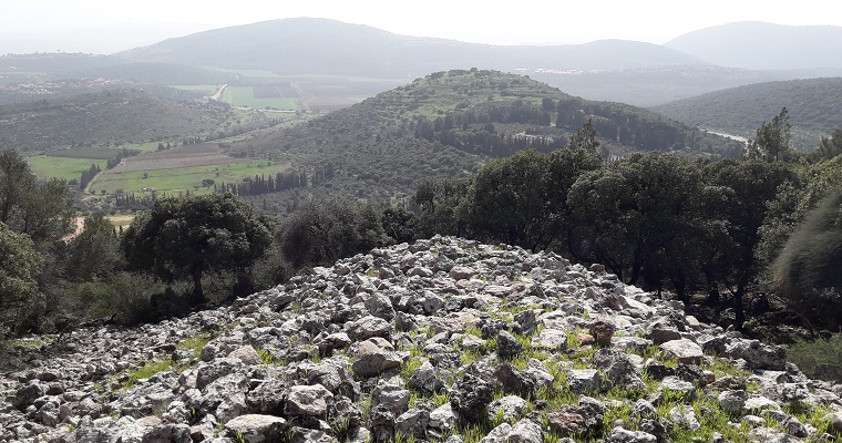
One of the earliest and largest cities in Israel was established on the shores of the Sea of Galilee, occupying the area now home to Beit Yerah High School and the Ohalo Hotel, adjacent to the renowned cemetery of Kibbutz Kinneret. Spanning approximately 3000 dunams, the settlement was home to about 6,000 people. It boasted fortified walls measuring 8 meters in thickness, a network of paved streets arranged in a grid pattern, grand public edifices, vast silos, and temples. Nestled between two branches of the Jordan River, which at the time diverged from the Sea of Galilee into parallel channels, Beit Yerah existed as a sort of island city.
The site was inhabited as far back as the Chalcolithic period, but with the advent of urbanization and the beginning of history, it underwent a significant transformation, assuming a new character. While much of the ancient city lies beneath modern structures, the northern section of the mound has been excavated and transformed into an archaeological park accessible to visitors. This park offers a glimpse of impressive discoveries from the beginning of history, as well as artifacts from later periods. Visitors can enjoy a breathtaking view of the Sea of Galilee and follow a path leading down to the lakeshore, continuing along the water’s edge.
In the archaeological park, visitors can find informative signs and observe remnants of palaces dating back to the Umayyad period. Notably, the ancient section closest to the Ohalo Guesthouse showcases impressive structures, including massive round silos dating back 5,000 years, spanning an area of 1,200 square meters. Positioned on a platform surrounding a courtyard and bordered by paved streets, these silos were a critical component of the city’s infrastructure. Seven large circular buildings, each serving as the base of a silo with an impressive diameter of 8 meters and towering 5 meters in height, encircled the open courtyard. Calculations indicate that these silos had the capacity to store over a thousand tons of grains, sufficient to sustain the city’s population of 6,000 for an entire year—a testament to the city’s advanced organization and agricultural prowess. Additionally, within the courtyard, there is a structure resembling an altar, suggesting a possible religious or ceremonial function, such as offering thanksgiving for the harvest. This unique silo structure is unparalleled elsewhere in the world, highlighting Beit Yerah’s sophisticated urban planning and agricultural management systems, comparable to those found in Egypt and Mesopotamia.
To achieve such substantial agricultural yields, it’s conceivable that large-scale irrigation was employed in the nearby Jordan Valley, renowned for its fertile terrain. The rise of significant civilizations like Sumer and Egypt was often precipitated by innovations in irrigation canal construction, facilitating centralized and coordinated agricultural endeavors. These irrigation networks effectively transformed water into a communal asset managed by the state, ultimately culminating in the establishment of temple cities where agricultural produce was centralized, stored, and redistributed under the auspices of rulers. Surrounding these temples, vast silos likely existed, fostering the development of artisan workshops and ancillary industries. This prompts the inquiry: Did Beit Yerah, and perhaps other cities like Jericho in the Land of Israel, adhere to a similar model? Could the temple lie beneath the Ohalo Guesthouse, awaiting discovery?
According to Sarit Paz and Raphael Greenberg, the city of Beit Yerah was governed by a public council representing various families and classes. Although inhabited during the Goddess culture period, the onset of history and the establishment of cities in Egypt and Sumer 5,000 years ago prompted the city’s leadership to orchestrate its transformation from a predominantly rural settlement into an organized urban center. It appears that the council implemented a comprehensive master plan, which included fortifying the city with walls, constructing public edifices, particularly expansive granaries, and laying out a grid of streets spanning the settlement from its southern gate to the northern region. The street system, anchored by tombstones outside the southern gate, follows a crisscross pattern, running parallel to the southern wall on one side while oriented towards Mount Hermon, the highest peak in Israel, on the other. This orientation, deviating 10 degrees east from true north, aligns with the distant view of Mount Hermon on clear days, offering travelers along the Long Streets a glimpse of the majestic peak.
Remnants of the streets have been unearthed in 12 excavation sites at Beit Yerah, all adhering to a consistent standard: a crushed stone base, often compressed gravel, topped with slabs of stone, primarily basalt sourced from distant locations, occasionally supplemented with pebbles from the Sea of Galilee. These streets were typically flanked by house walls, with drainage canals excavated alongside to manage rainwater runoff. The uniformity and pervasive use of the same construction techniques across multiple sites suggest centralized planning and likely adherence to construction standards, akin to contemporary public projects in Egypt. The execution of such a project on an urban scale indicates the ability to mobilize labor and advance projects of communal significance, indicative of authority wielded by governing bodies.
The urban layout of streets reveals a remarkable degree of organization and oversight, incorporating considerations of traffic flow, oversight, sanitation, and public health—hallmarks of a densely populated urban center. The point of origin for measuring the street network was a religious edifice outside the southern gate, symbolizing the propagation of the new order from this sacred focal point throughout the city. This religious justification is further evidenced by the orientation of the streets toward Mount Hermon, a revered peak. Remarkably, the street network was maintained and repaired over the course of hundreds of years, underscoring its enduring importance and the continuity of urban planning efforts.
The street network not only served functional purposes but also delineated boundaries of neighborhoods and individual houses, establishing ownership and subjecting the entire urban space to a system of laws and regulations. Unlike in villages where individual expansion was common, the city enforced uniformity and equality in housing and access to public spaces. Authorization was required for personal matters like drainage, transportation, and construction materials, indicating a centralized authority. Neighborhood divisions likely retained tribal elements or reflected emerging class distinctions and divisions of labor. The city was governed by a council comprising family heads and class representatives, suggesting a democratic structure rather than hierarchical authority prevalent in later periods.
The street layout of Beit Yerah indicates that the early cities in Israel were not developed organically over time like modern Arab villages but were planned and built in a coordinated manner, akin to some contemporary Jewish cities. Interestingly, similar street arrangements and construction methods are found in other cities from that era, including Arad, Tel Asur, and Megiddo. The construction of crisscrossing streets based on a grid originating from the monumental city gates is a feature found in Sumerian cities like Uruk and Ur, and it was also implemented in their colonies in northern Mesopotamia. Paz and Greenberg cite the city of Habuba Kabira in northeastern Syria as an example of orderly urban planning, suggesting that it may have influenced the urban planning in Israel during the beginning of history.
The name Beit Yerah, originating from the Talmud, likely preserves the ancient name of the settlement, suggesting an association with the ancient moon god (Yerah meaning moon in Hebrew). This reflects a duality between the gods of the ram, prevalent in Mesopotamia, and the gods of the bull, dominant in Egypt. This duality is often expressed through the worship of the sun in Egypt or the moon in Mesopotamia. In Israel, settlements in the east were naturally inclined towards Mesopotamian influences and associated with the moon deity, as seen in names like Beit Yerah, Jericho, and Hatzor. Conversely, settlements in the west leaned towards Egyptian influences and were associated with the sun deity, reflected in names like Beit Shemesh, Apollonia, and Afek.
In addition to its network of streets and silos, Beit Yerah was known for its distinctive pottery style, resembling that of the highlands in Armenia and Anatolia. This pottery involved sophisticated techniques of burning and glazing, resulting in vessels with red and black colors. Archaeologists speculate that this pottery was either crafted by expert potters who immigrated to Israel or imported from these regions. It is believed that immigrants from the trans-Caucasus regions settled in Beit Yerah, Hatzor, and Beit Shean, establishing centers for urn production that were exported across the country. The widespread presence of Beit Yerah pottery in Israel and neighboring regions suggests a thriving industrial production and active trade during that time.
The ancient city of Beit Yerah was mysteriously abandoned at the end of the period (24th century BC) and never regained its former glory. It saw periods of rebuilding during the Hellenistic and Roman eras, and even served as a residence for the Umayyad Caliphs during the early Arab period. However, it was eventually abandoned and destroyed once more. Today, visitors can access the area from the southern parking lot of Kinneret Cemetery.

A mysterious structure under the Sea of Galilee
About a kilometer north of Beit Yerah, just 100 meters from the shore of the Sea of Galilee, lies one of Israel’s and the world’s most remarkable and largest megalithic stone mound structures, recently discovered. Made of basalt boulders up to a meter in size, this giant cone measures 70 meters in diameter and 10 meters high. Part of this superstructure, the head, is submerged 2-3 meters underwater and can be seen from a boat. While its purpose, construction date, and builders remain unknown, it’s evident that considerable effort went into its creation.
Archaeologists, including Michael Freikman, attempted to date the monument. Freikman’s research revealed that the base of the stone cone is covered by two meters of clay sediment. Based on calculations regarding sediment accumulation in the lake over time, he estimates that the structure was built between 4,500 and 9,000 years ago. Freikman proposes that the structure, constructed 4,500 years ago, coincided with the existence of the ancient city of Beit Yerah. He suggests it may have been built by the city’s residents to prevent blockage of one of the Jordan River outlets from the lake, which existed north of the city alongside the one existing today (the river’s course has changed over centuries).
Other archaeologists have suggested that the construction of the stone cone occurred during the Early Bronze Age, around 5,000 years ago, which aligns with the accepted date for the construction of similar megalithic structures in the region, such as the Rujum Hiri stone circle. Additionally, nearby megalithic stone mounds like Gal Jethro or Mit’ham Levi’a further support this timeframe. The existence of the city of Beit Yerah during this period could have provided the necessary workforce and motivation to erect such a large and impressive structure, as settlements of similar size did not exist in the vicinity during earlier periods.
However, there is a significant blind spot in the arguments regarding the dating of the stone cone. It must have been built at a time when the Sea of Galilee was at least 10 meters lower than it is today, which occurred approximately 20,000 years ago. Ohalo 2, a site near Beit Yerah, was discovered underwater and contains burned huts preserved by the water’s rise 20,000 years ago. This rise in water level led to the preservation of organic materials within the huts. The water slowed down the decay processes and facilitated the preservation of these materials. However, if the village was submerged by water at that time, so too would have been the stone cone, making it impossible for it to have been built when the water level was high.
The archaeologists who propose a construction date of 4,500-5,000 years ago for the monument, such as Freikman, argue that a period of decreased water levels due to severe drought allowed for its construction. However, this explanation is contradicted by the preservation of organic materials at the Ohalo 2 site, indicating that the water level remained relatively stable over time. Furthermore, the absence of buildings in the area where the beach would have been if the water level were 10 meters lower suggests that such a scenario is unlikely. The Sea of Galilee is a closed basin, and fluctuations in its water level are primarily due to human activity such as over-pumping rather than natural droughts.
Considering these factors, it appears that the cone of stones is much older than the time of Beit Yerah, possibly dating back 20,000 years. While Freikman acknowledges the possibility that it may be 9,000 years old based on sediment measurements, the accuracy of such measurements is debatable. Future plans to use ultrasound to scan the structure may provide further insights.
If the cone near Beit Yerah was indeed built 5,000 years ago or less, as suggested by Freikman and others, it likely formed part of a larger array of megalithic structures in the Golan and Galilee regions. It could have served as a central point or world axis, akin to a world mountain, in the surrounding landscape. Additionally, its construction with large volumes of stones parallels the building of pyramids in Egypt during the same period.


The Giant Sacred compounds of the Golan
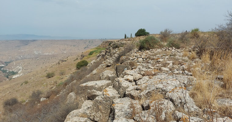
In the central and southern Golan Heights, overlooking the Sea of Galilee, recent discoveries have unveiled a series of sacred complexes characterized by massive stone ramparts enclosing their premises. Previously believed to be fortified compounds for defense, these sites are now viewed differently following excavations and Yitzhak Paz’s doctoral research. Paz argues that these complexes represent a unique form of urbanization unseen elsewhere in Israel and the world, emerging 5,000 years ago at the dawn of history.
The defining feature of these sanctified complexes is their embankments constructed from enormous piles of basalt stones, reaching heights of 10 meters or more, reminiscent of the tumulus at Rujum Hiri. These embankments, sometimes spanning up to 30 meters in width, required significant labor for their construction. Situated on the eastern side of mountain spurs, these complexes are strategically positioned, often overlooking the Sea of Galilee from a distance and surrounded by natural cliffs and slopes on other sides.
The array of sacred sites around the Sea of Galilee
To begin, it’s important to recognize that ancient cities were often considered sacred sites, their plans and locations believed to be ordained by the gods. We’re discussing an array of ancient cities and megalithic compounds found within a 30 km radius of the Sea of Galilee. These sites exhibit interrelation in their dimensions, building materials, shapes, orientation towards prominent landscape features like mountains or the lake, and towards each other.
The appearance of massive megalithic monuments, ramparts, semi-stone circles, stone circles, cities, and burial complexes (dolmens) is interconnected, forming a network of sacred sites around the Sea of Galilee, spanning the highlands overlooking it from the Golan and the Galilee. In essence, tens and hundreds of thousands of working days were invested to create a complex and complete set of cities and megalithic sacred sites around the Sea of Galilee, with the lake itself serving as the central point.
Currently, three settlements have been discovered around the lake: Tel Yerah, Tel Raket, and Tel Kinneret. Additionally, two massive megalithic structures are located near or in the lake: the pyramidal cone near Bet Yerah and a large stone circle found recently north of the Sea of Galilee in the area of Buţayḩah. The stone circle, measuring 56 meters in diameter with three circles concentrically arranged, is particularly intriguing. It sits on a line connecting the sacred precincts of the Golan with those of the Galilee, aligning the ancient fortified compound of Gamla with the Gal Jethro site at the foot of Mount Meron.
To the northeast of the Sea of Galilee, there are nine megalithic compounds, six of which are sacred fortified compounds situated on spurs overlooking the Sea of Galilee. These compounds, surrounded on three sides by cliffs and on the fourth side by massive stone embankments, include Bradauil, Levia, Gamla, Aniam, Yehudia, and Yitzchaki. Additionally, there are three similar sacred compounds on the plateau without surrounding slopes: Shabania, Bajuria, and Aiit. It is believed that there may be more undiscovered sites in the area.
Among these complexes, the southern ones (Bradauil, Levia, and Gamla) are relatively large (around 100 dunams) and spaced farther apart, while the complexes overlooking the Sea of Galilee from the northeast are smaller and closer to each other. Gamla serves as a link between the northern and southern complexes, as well as between those within the plateau and those on the edge. While Gamla is likely the largest complex, the Levia compound is the primary site for research due to its better-preserved ancient settlement remnants.
On the opposite side of the Sea of Galilee lies the site of Gal Jethro, featuring a massive megalithic half-circular stone embankment similar in style to the Golan sites. Although its purpose, builders, and exact construction date remain unknown, the semi-circle of Gal Jethro is oriented towards Mount Karnei Hitin, which overlooks the Sea of Galilee. This mountain, named for its horn-like shape, likely held sacred significance in ancient times and has similar Megalithic embankments.

Levia embankment

Levia compound
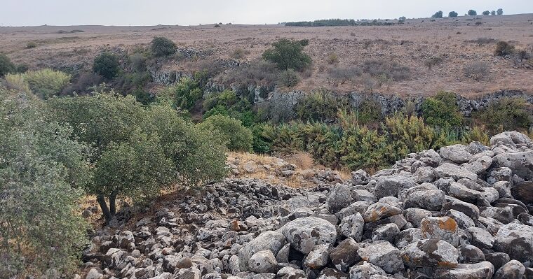
At the transition from the Goddess culture period (Chalcolithic) to the beginning of history, there was a significant shift in settlement patterns in the Golan. Previously, the population was dispersed among rural settlements located near river channels. However, with the advent of history, there was a trend towards establishing larger towns situated in elevated positions, away from water sources. These new settlements were characterized by clear boundaries demarcating the inside from the outside, symbolizing the order of the new society amidst the chaos of the surrounding world. One notable settlement from this period is the Levia compound, which has been recently excavated by Dr. Yitzhak Paz, providing valuable insights into its nature.
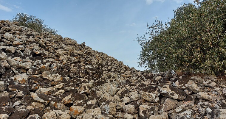
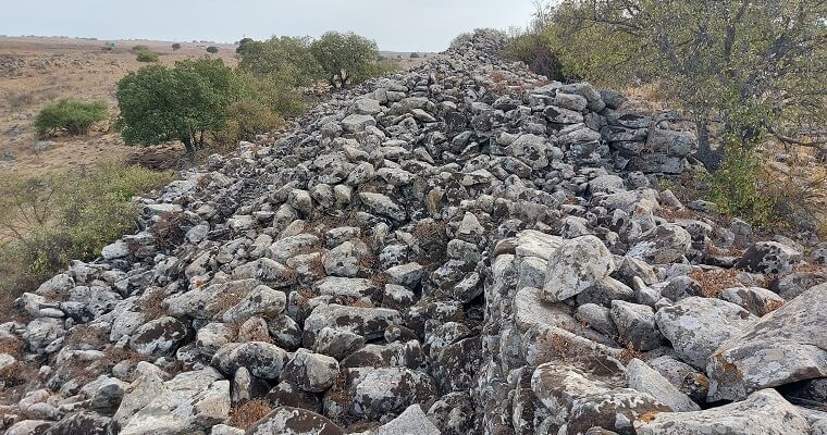
The Levia compound is located on a mountain spur surrounded by cliffs on three sides, with a massive stone embankment stretching along its eastern side for over 200 meters. This embankment, constructed from 14,500 cubic meters of stone, is 16 meters wide and 10 meters high. Given its size, it is unlikely that the embankment was solely intended for defense purposes. Archaeological evidence suggests that each layer added to the embankment was part of a ritualistic practice, perhaps imbuing the structure with symbolic significance.
Professor Philip Graham suggests that these colossal embankments were built layer by layer, with each generation adding to the structure. They served not only as physical barriers but also as ideological symbols of power and land ownership. These walls delineated the boundary between those within the societal order of the city and those existing outside it in a “barbaric” manner. Moreover, the construction of these embankments was a communal effort, reinforcing a sense of collective identity and belonging. Additionally, it’s conceivable that these embankments held magical significance, acting as mystical boundaries separating the sacred from the profane. Many of these fortified (sanctified) compounds were strategically situated in prominent locations, despite their inconvenience in terms of proximity to agricultural fields. This suggests that their visibility from a distance and their specific location held some form of magical or energetic significance to their builders.
In this context, it’s noteworthy that artificial earthen and stone embankments are common features of ancient sacred sites worldwide. Often, these embankments encircle sacred precincts where seasonal religious gatherings took place. Similar features can be observed at the dawn of history in Egypt and in locations such as England, France, and Spain. For instance, Stonehenge exhibits an early phase of earth embankments dating back to the 3rd millennium BC, along with over 70 other battery complexes from that era all over south England.
The Levia compound encompasses an area of 90 dunams. The narrow spur is protected by a substantial embankment of piled stones, as described previously. Additionally, on its other three sides, there are remnants of a deteriorated wall serving as fortification. Approximately in the middle of the spur lies a thick inner embankment, alongside which archaeological excavations have revealed houses equipped for various activities. These included facilities for olive oil production, pottery brought from Bet Yerah, fragments of simple urns, evidence of animal husbandry, and more. Initially, the site was thought to be a parking site for nomadic tribes, but recent excavations have unveiled an ancient city with buildings, streets, and areas designated for public use.
In the southern part of the outer embankment, a gate structure was uncovered, bearing signs of a battle that occurred in the 24th century BC. Adjacent to the gate were two towers and a protective wall. Despite these defenses, an attacking force armed with sling stones and clubs breached the gate, captured the city, and set it ablaze. Yitzhak Paz estimates that around 1,400 people inhabited Levia at the time, suggesting that conquering a fortified settlement of this magnitude would require an attacking force of at least 1,800 individuals, with a ratio of 1:6 in favor of the attackers. However, it remains unclear who could have organized such a sizable army during that period. Unlike Sumer and Egypt, the Land of Israel lacked a centralized organization and kingdom, instead adopting a decentralized structure of city-states that were ill-equipped to support large military endeavors.

Barduil spur
Bardauil compound
The Bardauil compound, located at the southernmost point of the six Golan complexes, features a relatively low outer wall encompassing a large area, as well as a massive inner wall—an immense stone embankment—bordering a small spur of the plateau above the cliffs of Nahal El Al. This embankment, reaching heights of up to 12 meters and widths of 30-40 meters, raises questions regarding its purpose. Yitzhak Paz suggests that it served as a ritual element rather than a fortification, akin to Gal Jethro and the stone circle of Rujum Hiri.
The Bradauil compound, situated high on the Golan plateau, offers a commanding view of the Sea of Galilee below, making it a prominent landmark visible from a distance. The imposing embankment further accentuates its prominence, potentially serving as a beacon when torches were lit atop it during dark nights or if the structure was more intact in ancient times. This suggests one of its possible functions as a marker or landmark. Despite its visibility, the area behind the embankment was not conducive to supporting a fortified settlement due to the lack of water sources at the end of the spur and limited space. However, it was well-suited as a gathering place, meeting point, or temple, located atop a prominent spur that offered expansive views of the Sea of Galilee, the Galilee region, and the Buţayḩah Valley.

Yitzhaki compound
One of the most remarkable sites in the Golan is the Yitzhaki “compound,” named after Yitzhak Gal, the explorer who first discovered it. You can embark on this discovery yourself, and trust me, the effort is truly rewarding. From the waterfalls junction, trek about a kilometer toward the spur situated between the two branches of Nahal Yehudia, heading southwest until you encounter a substantial embankment of stones stretching between the northern and southern valleys. This embankment, standing 2-4 meters high and 4-8 meters wide, appears to form a barrier or protective wall shielding the southwestern part of the spur. On its northern side, there’s an opening facing Mount Avital, towering over the nearby hills.
Continuing along the spur, you’ll encounter another massive embankment of stones, towering over the adjacent trees to a height of over 10 meters and spanning an unimaginable width of 10-20 meters. This immense inner rock embankment, enclosing a relatively small portion of the spur (20 dunams), presents a puzzling sight, given the monumental effort invested in its construction. Unlike the Levia compound but reminiscent of the Bardauil compound, this site features a towering inner embankment alongside a “normal” outer embankment. It’s evident that the inner embankment wasn’t erected for defensive purposes, despite some identifying what seems like walls and towers atop it. However, even these supposed towers wouldn’t serve for defense. If establishing protected settlements in the Golan was the goal, it would make sense to position them atop the summits of volcanoes a few kilometers east or on protected spurs descending toward the Sea of Galilee, such as Gamla a few kilometers southwest. Additionally, the lack of water cisterns within the Yitzhaki compound’s small internal area makes it an unlikely candidate for fortification.
Like several other “compounds” in the Golan, the Yitzhak compound offers a commanding view of the Sea of Galilee, encircled by deep gorges on three sides and separated on the fourth by an embankment from the plateau. Although pottery from the beginning of history and remnants of square buildings have been discovered within the compound, it has yet to be fully excavated. Adjacent to it are three other compounds: the Aniam compound (17 dunams) near the Aniam industrial area, the Yehudia compound (30 dunams) southeast of the Itzhaki compound near the Yehudia gorge, and the Ait compound (7 dunams) on the southern bank of Nahal Ait. Together, these four complexes cover a total area of 74 dunams. If these compounds were intended for defense, one might question why a single fortified site wasn’t constructed. To put it into perspective, the Levia compound alone spans more area (90 dunams) than all four northern compounds combined.
Moreover, these four compounds are situated just a few kilometers from Gamla, a relatively sizable site from that era (130 dunams) naturally fortified on all sides. In the event of an enemy threat or approaching army, seeking refuge in Gamla would have been feasible, a strategy utilized 3,000 years later during the Great Revolt against the Romans when Jewish inhabitants from Galilee villages sought shelter within the city and its citadel. No grand buildings, temples, or monuments have been unearthed within the compounds themselves, which one would expect to be crucial to protect at all costs. Any damage inflicted on villages during occupation was likely minimal, with houses easily restored, indicating that the primary objective during times of conflict was to safeguard lives until the threat subsided. This would necessitate larger and more fortified compounds than those previously mentioned.

Gal Jethro
The array of sacred sites from antiquity extends from the Golan on the eastern side of the Sea of Galilee to the Galilee on the western side, with each site interconnected and bearing significance in relation to the Sea of Galilee. Among the notable sites in the Galilee are Gal Jethro, situated at the base of Mount Meron, and Mount Karnei Hittin overlooking the Arbel valley, both of which share a relationship with each other.
Gal Jethro, located on the southern slopes of Mount Meron, stands as one of the most remarkable megalithic sites in the region. It comprises a massive semicircular stone embankment measuring 150 meters in length, 20 meters in width, and 7 meters in height. With 14,000 cubic meters of stone, its volume rivals that of the embankment at the Levia compound, establishing an intriguing connection between various megalithic sites of the same era. Notably, this volume is akin to that of Rujum Hiri, which also contains approximately 13,000 cubic meters of stone.
The site, explored by archaeologist Ido Wachtel in 2012, poses challenges for access, situated along unmarked paths on a mountainside several tens of meters above the Parod springs and several hundred meters from the settlement of Parod. The builders and purpose behind Gal Jethro remain elusive, although Wachtel suggests a dating to the beginning of history around 5,000 years ago, though some evidence hints at an older origin. Its resemblance to Rujum Hiri, coupled with similar archaeological findings, suggests a possible Chalcolithic period origin, as proposed by archaeologist Michael Freikman.
Unlike the enclosed area of the Levia compound, Gal Jethro’s embankment does not define a specific space. Situated on a sloping spur surrounded by slopes rather than cliffs, it reinforces the notion that these immense embankments held symbolic, religious, and magical significance rather than purely defensive purposes.